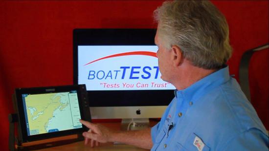
SiriusXM Marine Weather

Others may feel differently about some of the observations I make here, and that’s okay. You can write about it on your website. But the simple fact is, I’m a for-real professional boat captain. I don’t just test drive boats, I work on them. And this service, like the cellphone, has become a vital tool for me. And like the cellphone, everyone uses it differently. What follows is how I use this service on my display on my boat. It’s not the only way, but it may form the basis for how you would use it.
Dispelling the Myths…
Do all boaters need it? This one’s easy… nope. We can all agree that it’s not for everyone. Now before you click away in your browser, there are some considerations to determine if you are one of those boaters that may or may not need/want this service.
If you spend your days hanging around the dock or not far from it, well then weather concerns are probably at the bottom of your list of priorities, while beer and sandwiches are closer to the top. This is understandable and this type of boater is certainly not in the Sirius target audience.
But I’ve seen boaters in these categories spend $20,000 for a position-keeping option on their boat because they don’t like to manipulate the controls while holding for a bridge or a fuel dock. The “wow” factor alone may entice most of these boaters to this service.
However, if you make continual runs offshore, are gone for extended periods or take people for hire, then you are absolutely square in the sights of the target audience. These are all boaters that have a vested interest in not only getting themselves back safely but others as well. And of course, with that said, they also have an interest in making the decision to go in the first place. Weather information is critical to all these operators.
Yeah, There’s an App for That.
So ask anyone what the weather will be and what happens. They reach for their phones. We all have one, they all have weather apps, and for the most part, they’re free. So give me one good reason why I need to have a subscription service to tell me what I can already get for free?
I’ll give you three…
- Cellphones have a limited range. Get from 6 to 8 miles offshore, and in some cases, not even that far, and that cellphone you rely on so much just became a paperweight.
- Apps need to update to be current and reliable. I’m not talking about getting v12.67 instead of v12.66, I’m talking about updating the current weather so you’re not reading stuff that’s from yesterday. So you either start up the app before you leave or don’t go out of cellphone range. Otherwise, you’re looking at old information and will think it’s fresh. It isn’t.
- To me, this is the most important. I’m a professional. I’m not just a BoatTEST captain, I actually work as a professional captain carrying passengers and everything. Sometimes I even wear those gold stripes. My point is, when I need to make an informed decision, or want valuable information, the last thing I want to have to do in my commercial bridge, diverts my attention, time, and hands to a cellphone. Not when I’ve got the best-of-the-best of marine electronics spread out in an array in front of me.
(No, I don’t even take phone calls when I’m running a high-speed ferry at 30+ knots.)
Instead, I, or my first, will retrieve the information from the displays in front of me. It’s part of bridge management and every boater would be well advised to emulate it. There’s a yacht at 300-degrees and 20-relative… I need its name, heading, speed, CPA (closest point of approach) and TCPA (time of closest point of approach) and I need it NOW. It’s no more than two button presses away from being up on both my 24" (61 cm) display and my radar. Not on my phone.
I need to know if my trip to the Canyons will be safe for the next three days because that’s how long I’ll be out there and shelter is a long way off. My phone is useless and even if it weren’t, I want it displayed in front of me so I can scan the rest of my displays and make an actually informed decision. Right here, right now.
To the professional, phones are a joke. To the serious boater, they usually are. To the day-tripper… by all means, embrace them.
It’s Expensive
Are you kidding? We already discussed that the target audience is the offshore boater, professional or personal. The boats that are used for that sort of boating cost as much, and more often than not more, than a house. And you’re going to complain about a monthly subscription that’s less than your cable or phone bill?
So What Do We Get with SiriusXM?
First, my two favorites.
Sirius provides a wealth of information and some of it you’ll look at all the time and some only once in a while. Like anything else, the more you use it, the more intimate you’ll become with it and suddenly you start to develop favorite features. For me, there are two.
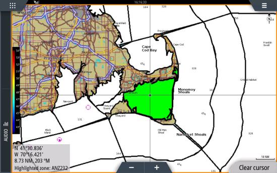
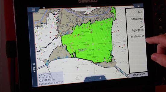
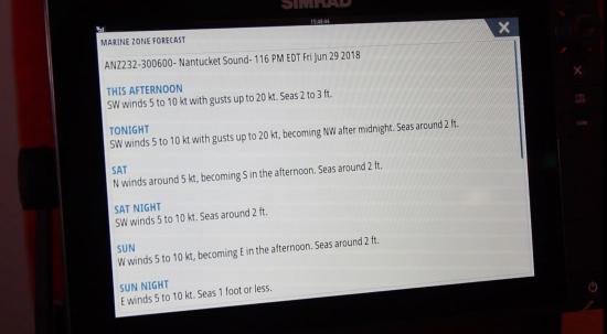
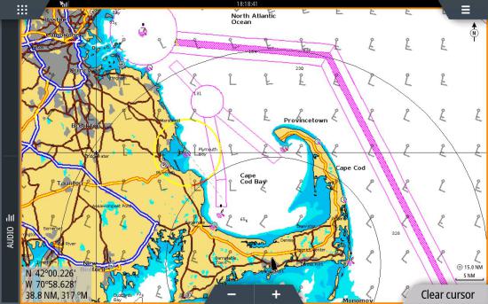
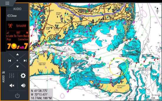
The Marine Zone Feature.
Picture yourself pressing the WX button on your VHF and “Mechanical Mike” starts his monotone weather report for an area covering 200 square miles from your current position. You wait 20 minutes for it to get to your area but by then your attention has wandered, the phone rang, the crew starts talking… and you miss it. Now you have to wait another 20 minutes for it to cycle back to your area.
With the Marine Zone feature, you get the weather for the area you select, and that’s it. Everything else is left off the table. This is important since we only care what’s going on in the zone we’ll be operating in. If we’re crossing the ocean, then, by all means, select the next zone along the route and look ahead.
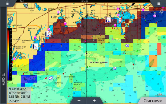
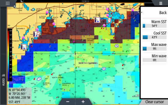
SST.
Another cool feature that I like to gravitate to is the SST or Sea Surface Temperature. Party fishing boats are among the many I run, and in my home waters, the fish are very much drawn to waters of a certain temperature range. That makes the sea surface temperature feature critical, for me and for any fisherman. It’s gathered from infrared satellite imagery, not guesses or somebody reporting back the temperatures from his boat.
I use the SST feature to find that specific temperature range. That allows me to put the boat on the meat when someone half a mile away is getting nothing. Does this make me a better fisherman than those guys? Yes... Yes, it does. And my passengers buying tickets to my boat would agree.
It’s available in two forms color and text. The text gives just small numbers across the screen and it’s harder to tell trends with that. Probably good for swimming, but I need to see areas of equal temperature and boundaries, and that means color for me.
Ok, so much for my favorite two. Let’s take a look at the rest of the features. It’s basically broken down into two categories; View and Icons.
The View Features
- Precipitation: Precipitation is exactly what you think it is… rain. Activate this feature and you can see where the rain is.
The wave feature tells you the wave height, period, and direction at a glance. I use the “Observations” feature, which we’ll discuss shortly, to get my wave detail though. But that’s me.
Select “wind” and up pops wind barbs. Again, a glance tells you wind direction and velocity to the nearest 5 mph. It does this with the standard wind barbs that anyone who watches the weather channel will be familiar with. They look like flags with the short barb indicating 5 mph, long indicating 10. Add the shorts and the longs for the total wind speed. The barb rotates around a small circle, and wind blows from the barb to the circle.
- SST Colored - SST Text: We covered this above in the “My Favorites” section. If you’re fishing, this is a must-have feature.
- Wave
- Wind
Activate the surface features and you’ll want to zoom out for this. It gives isobars showing areas of pressure… low, high, stationary fronts… etc. Lows will bring snotty weather, highs will be calmer, and stationery will usually be rainy.
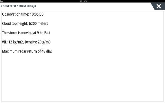
Cloud tops are simply where clouds are, meaning areas where you could be out of direct sun. Echo tops will show where the convective activity is likely. The higher the echo top, the more severe the storm activity is likely to be in that area. I use these features sparingly as they look like the precipitation feature, but, when I do use them, it’s mostly Echo Tops. I’ll then skirt the higher, and therefore more severe, weather and can sometimes buy myself another hour of weather avoidance on my way back from an offshore run.
- Surface Features
- Cloud Tops, Echo Tops
The Icon features
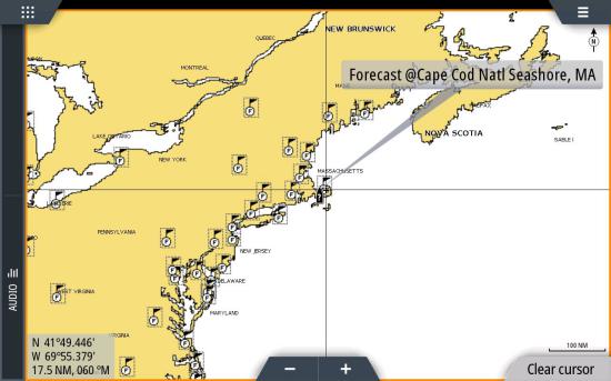
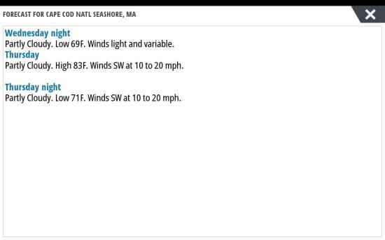
Activate this feature and look for a small flag with an “F” on it. Touch it and get a pop-up box, touch the data in the box and you’ll get a broad scale short term forecast of what conditions will be like... i.e. cloudy today, partly sunny tomorrow…etc. The “marine zone” feature drills down to more detail for your specific area.
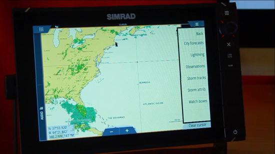
- City Forecasts
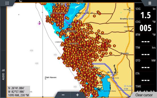
This is big. These are exact locations of where a lightning strike has occurred within about the last 10 minutes.
- Lightning
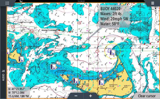
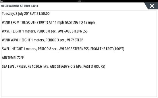
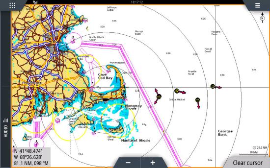
Observations are like looking at a data buoy. Activate this feature and we see buoys with small “W’s” on them. Touch one and a popup shows the basic info. Touch the popup and we get a more detailed look with a blue bar (on my display…. more on that later). Touch that blue bar and drill down to very specific info on the current observation.
- Observations
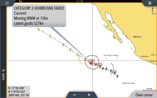
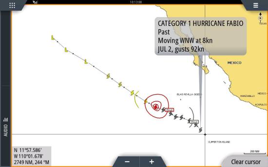
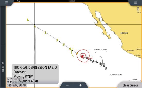
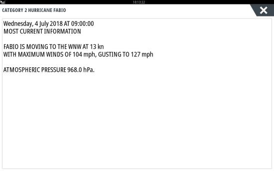
This is for your larger weather… think named storms. You can follow the track from where it originated and its projected course. There are also markers that you can touch to get either a historical version of course, travel speed, and wind speed… or the same information projected ahead.
- Storm Tracks
Storm Attrib(utes) shows the individual storm cells and their projected course of travel… something that is greatly beneficial. Plus, by touching on an individual cell, a popup box appears… touch it for more detailed information.
- Storm Attrib
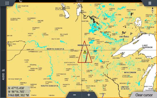
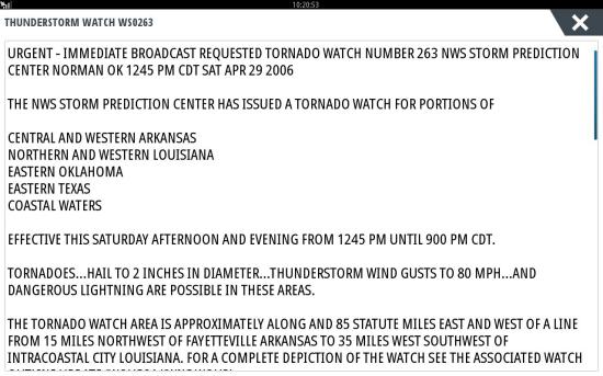
When you have a weather alert on your VHF, that is generated from a watch area... “a thunderstorm watch is in effect for the area extending from Watch Hill, RI to Gloucester Massachusetts...” Blah, blah, blah... Well, the watch box highlights that area and keeps watch on it, plus you can touch it to get a popup for a more detailed outlook of the area and what it is watching. Sometimes it’s an actual box, other times it’s a triangle, I’ve even seen trapezoids.
You don’t want to leave this feature on because, at least on my Simrad unit, it eats up bandwidth that slows the processor down.
- Watch Boxes
Controlling What We See
In addition to displaying the above information, we can also control the flow of that information in several ways.
- Local Weather - For example, we can select “Local Weather”. This gives us the current weather for the zone we selected and we can look ahead with hourly or daily information by selecting the desired tab.
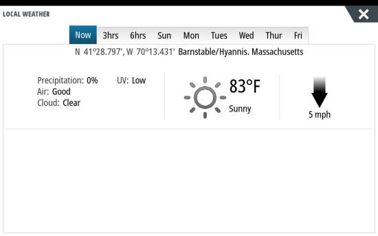
Now, this is something you turn on, view it, and then turn it off. It uses a lot of processing power in the MFD and slows down other features. Additionally, you don’t want to look at the screen and mistake what might be forecast for tomorrow for what is happening right now.
- Marine Zones – As discussed earlier, this will allow us to get a flow of information relative to the area of our choosing.
- Tropical Statements – this is for the ocean-going traveler. It’s a broad scale weather synopsis.
- Adjust – We can adjust the scale for the temperatures being shown, and the range for the wave heights, both from the minimum and maximum scale.
- Animate – It’s not good enough that we can see that there’s rain where we are… after activating the rain feature, go to Animate and see where the rain came from. It won’t show a projection, just a historical view, but it’s hugely beneficial. We can go back 3 hours and view in three different speeds. Winds, on the other hand, will give you a projection up to 2 days ahead.
- Transparency - Everything is overlaid onto your chart. Do you want to see through the stuff, or have it cover it over completely? The transparency setting allows control over this.
How current is this information?
The way SiriusXM works is like this: Specialists in the field compile the data from satellites. One is Baron’s and the other is The Weather Channel. So people need to touch the information before you see it. These people sort, compile and clean the data so that it’s readable. They also prepare forecasts and computer models of the weather picture. That’s one reason why it’s not instantaneously being delivered to your screen. Nor should it be. It would be too hard to interpret and we all can’t be meteorologists.
Reason two is the simple fact that satellites aren’t always passing overhead. As wonderful as your boat is, the satellites don’t revolve around it. Here’s the breakdown of timing…
- Sea surface Temperature – The infrared satellites pass every 3 hours, Sirius rebroadcasts every hour.
- Wind – Updates every 20 minutes.
- Forecasts – The 3-hour forecast updates every hour. 24 hours and higher are updated every 2 hours.
- Precipitation – This is not satellite-based, it’s coming from Nexrad radar. It updates every 4 to 5 minutes.
- Lightning – Updates every 2 minutes.
One other takeaway of this system is that your multi-function display need not be receiving GPS information. Even though for most brands, the satellite information is overlaid onto the map display, the Sirius aspect works independently of the GPS. You’ll get the proper information on the map regardless of where the map thinks it is. Now, about that “most brands” comment I just made…
Model Specific – Different Interface on Different Models
It’s important to know that Sirius just transmits its information. It’s up to the manufacturer of the specific display as to how, when and what is shown on the screen and how the menus control that information. Some will have popups for different information that needs to be touched. Others will have all the info right in the pop-up.
When the wind barbs are showing, some will always show it at all levels of zoom, others will remove it when you zoom in close to eliminate screen clutter. That one actually makes sense because you can see what the wind is doing around your boat, so why show it on the screen? Save it for zoomed out views.
Another example is something like a Raymarine won’t even show an overlay except for precipitation and lightning. Everything else is on a separate page. The point being, Sirius doesn’t design the interface, the manufacturer does. Same with the radar, sonar…etc.
That said, to their credit, Sirius is working with the individual manufacturers to address the levels of disparity between brands, but it’s an uphill battle. It may not happen overnight, but changes are taking place over time. For example, older units used to show the winds as little pennants on a staff. Now all are showing the more universal wind barbs that are more recognizable. Small steps.
So, Let’s Get Practical
Okay, so we have all of these great features at our fingertips, and it’s a lot. Realistically, how do we look ahead for danger here? Well, here’s how I do it.
- First, there’s wind. It affects my boat and passengers directly so I want to see what is coming and what I can expect. This forms the basis of my go/no-go decision. If I’m staying at the dock, none of the other features matter anymore.
- Marine zones are next. I get a detailed outlook of my specific area.
- Lightning is next. I want to know if there’s any out there and avoid it.
- Precipitation is last. I want to see what the deal is with rain and where it came from. I really don’t care about getting wet, but I do want to know if it will be all day or just part of the day.
After all of those steps, I will likely dabble and look at some of the other features, storm tracks and storm attributes… for a bigger picture, but that’s the nuts and bolts of how I do it.
Observations
I started this report by saying I was a Sirius geek, and I meant it. Just as with borrowing tools, other boaters who know I have this are calling me asking what’s up with the weather for tomorrow and to send a screenshot of where the colder water is. And just as with those borrowed tools, after you borrow it once, you buy it for yourself (guy code). My use of this service has generated scores of new customers for SiriusXM Marine Weather. And I see no problem with that.
And since you now have the receiver for the weather, it stands to reason that a subscription to the music side of Sirius would follow. It’s coming from the same receiver and all functions can be controlled from that same multi-function display and piped through the boat. Sirius-ly…