Atlantic 10-Knot Speed Limit in Effect for Boat 65’+
Owners and operators of boats and yachts 65 feet and larger are reminded that seasonal management areas (SMAs) are now in effect along portions of the East Coast. These zones limit speed to 10 knots during specific times of the year to reduce the risk of vessel strikes to the endangered North Atlantic right whale. They remain in place through April 30.
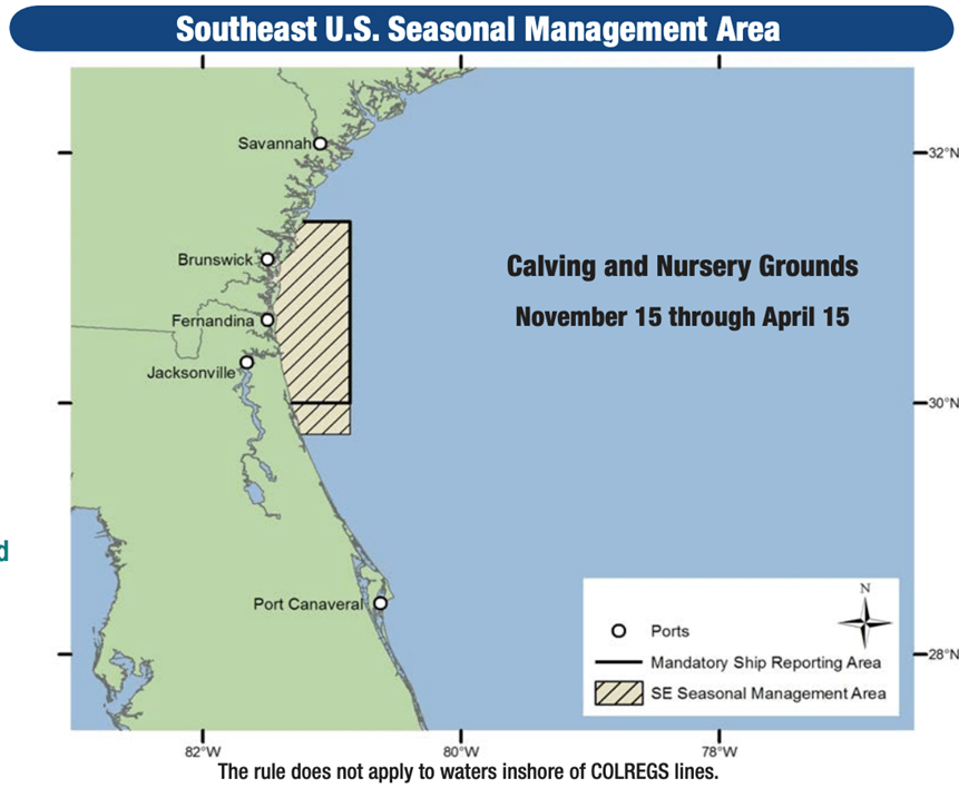
The SMAs include waters around entrances to major Northeast ports and nearshore areas extending up to 20 miles offshore from Cape Fear, N.C., to just south of St. Augustine, Fla. Additional calving and nursing areas off the Southeast are in effect Nov. 15 through April 15. Details and maps are available on NOAA’s Seasonal Management Areas page.
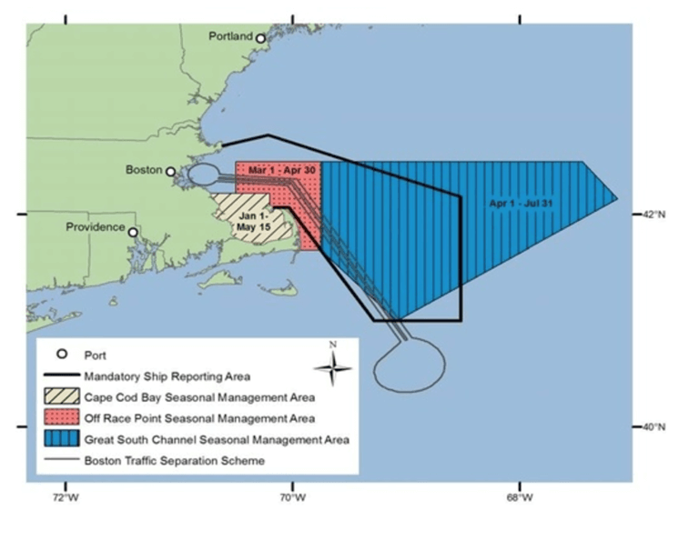
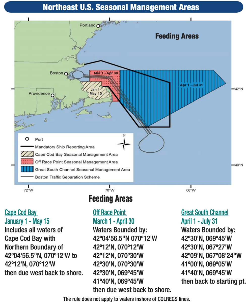
Cape Cod Bay, January 1–May 15
Includes all waters of Cape Cod Bay with Northern Boundary of 42º04'56.5"N, 070º12'W to 42º12'N, 070º12'W then due west back to shore.
Separate from the federal speed regulations in the Cape Cod Bay SMA, Massachusetts state law requires most vessels less than 65 feet to travel at 10 knots or less in the Cape Cod Bay Vessel Speed Restriction Area from March 1 to April 30. In 2025, the Massachusetts Division of Marine Fisheries (DMF) extended speed restrictions through May 15, 2025, due to the continued presence of right whales in Cape Cod Bay. Please visit the Massachusetts DMF website for information on state speed restrictions and advisories.
Off Race Point, March 1–April 30
Waters Bounded by:
42º04'56.5"N, 070º12'W
42º12'N, 070º12'W
42º12'N, 070º30'W
42º30'N, 070º30'W
42º30'N, 069º45'W
41º40'N, 069º45'W then due west back to shore.
Great South Channel, April 1–July 31
Waters Bounded by:
42º30'N, 069º45'W
42º30'N, 067º27'W
42º09'N, 067º08'24"W
41º00'N, 069º05'W
41º40'N, 069º45'W then back to starting point.
Migratory Route and Calving Grounds, November 1–April 30
Block Island Sound waters bounded by:
40º51'53.7" N 070º36'44.9" W
41º20'14.1" N 070º49'44.1" W
41º04'16.7" N 071º51'21.0" W
40º35'56.5" N 071º38'25.1" W then back to starting point.
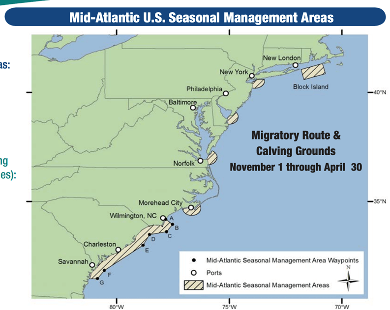
Within a 20-nm (37 km) radius of the following (as measured seaward from the COLREGS lines):
-Ports of New York/New Jersey: 40º29'42.2"N 073º55'57.6"W
-Entrance to the Delaware Bay (Ports of Philadelphia and Wilmington): 38º52'27.4"N 075º01'32.1"W
-Entrance to the Chesapeake Bay (Ports of Hampton Roads and Baltimore): 37º00'36.9"N 075º57'50.5"W
-Ports of Morehead City and Beaufort, NC: 34º41'32.0"N 076°40'08.3"W
Within a continuous area 20-nm from shore between Wilmington, North Carolina, to Brunswick, Georgia, bounded by the following:
A- 34º10'30"N, 077º49'12"W
B- 33º56'42"N, 077º31'30"W
C- 33º36'30"N, 077º47'06"W
D- 33º28'24"N, 078º32'30"W
E- 32º59'06"N, 078º50'18"W
F- 31º50'00"N, 080º33'12"W
G- 31º27'00"N, 080º51'36"W and west back to the shore.