The Carolina Loop: A Cruise through History
By Bill Hezlep
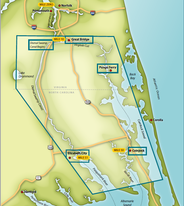
If you are out messing about in your boat and find yourself down at the bottom of the Chesapeake Bay, give a little thought to taking the "Carolina Loop." The Loop begins at mile 0—the official start of the Atlantic Intracoastal Waterway—and runs clockwise south through the Albemarle and Chesapeake Canal to Albemarle Sound and then back north by way of the Dismal Swamp Canal. It's a great trip through some of the Tidewater area's less well-known cultural and commercial history.
From the Waterside Marina in Norfolk or the Tidewater Yacht Marina in Portsmouth, both just south of Elizabeth River Red "36", the canal loop cruise is a pleasant and easy one. Even a slow sailboat can make the entire loop without undue stress, hassle and hustle in a week or less.
Start the Carolina Loop by following the ICW markers down the western branch of the Elizabeth River through the long, controlled wake zone and past the commercial cargo terminals, shipyards and naval facilities that line the river. This takes you to the high Interstate 64 Bascule Bridge (ICW mile 7.1), which clears 65 feet...closed. Immediately south of the I-64 bridge the two routes to Albemarle Sound and points south will divide. Stay on the western branch of the Elizabeth River for Great Bridge, the tide lock and the Albemarle and Chesapeake Canal. Turn west, past the Chesapeake Yachts haulout facility, to reach Deep Creek and the Dismal Swamp Canal if you want to do the Loop in a counterclockwise direction.
Generally called the "Virginia Cut," the eastern (and clockwise) Albemarle and Chesapeake Canal is the larger and more commonly used and the route used by all commercial vessels. The canal begins at the massive, 600-foot long by 72-foot-wide tide lock in Great Bridge, VA (ICW mile 11.3). This huge lock, built by the Corps of Engineers in 1932 to replace an older, smaller lock, separates the tidal and brackish waters of the Elizabeth River from the non-tidal and much less brackish waters of the Albemarle and Chesapeake Canal.
Between the tide lock and its junction with Albemarle Sound, the canal follows the 13-mile-long, manmade Virginia Cut; runs down the winding North Landing River to the dredged channel through broad, shallow Currituck Sound; leaves the sound through the short Carolina Cut; and then follows the North River to its mouth and Albemarle Sound (ICW mile 85).
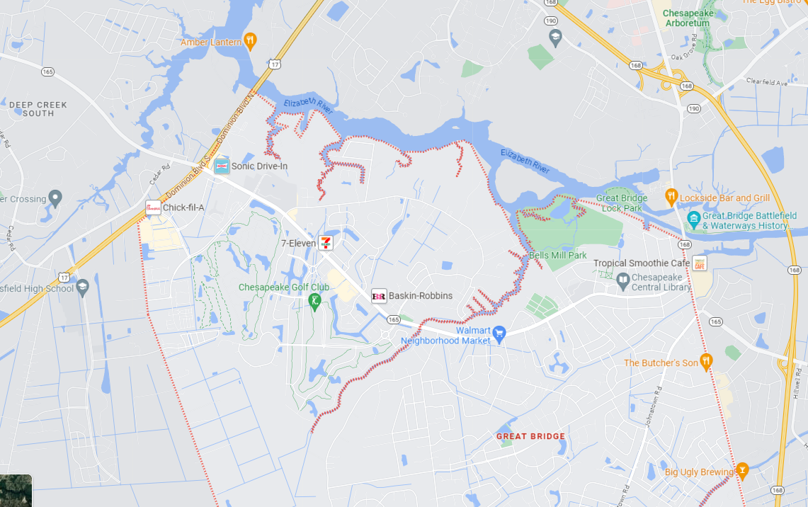
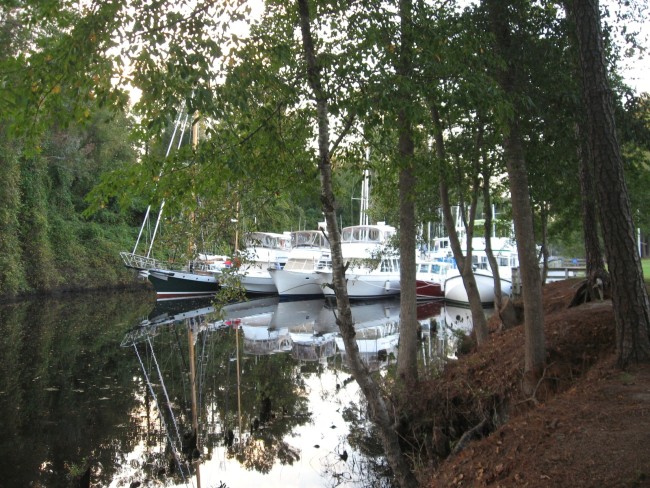
Great Bridge, a community in Chesapeake, makes a good first day-on-the-loop lunch stop or overnight stop on the Virginia Cut. Between the lock and the Battlefield Blvd. Bridge (the Great Bridge) a well-built wooden bulkhead on the right or west side (actually south side here, where the canal runs east--west) provides free overnight dockage (no facilities). Below the bridge, on the west side, the Atlantic Yacht Basin (ICW mile 12.2) offers overnight dockage, fuel and all the amenities of a good full-service marina, and on the east side a free dock (no facilities) that is part of the Great Bridge Battlefield Park provides a place to tie up.
It is worth noting that Great Bridge is a very popular stop with ICW cruisers and during the spring and fall snowbird migrations, boats headed for, or returning from, the warm winter weather and clear clean waters of the Bahamas and south Florida frequently crowd the docks and the bulkhead; rafting is socially acceptable.
Just a short walk along Battlefield Blvd. from the bridge brings you to numerous shops including an excellent supermarket and restaurants that range from fast food to fine dining.
While several skirmishes were fought in the Great Bridge area during the Civil War, the Battlefield Memorial Park at Great Bridge commemorates the battle fought on December 9, 1775. The battle, sometimes referred to as "the second Bunker Hill," was a significant early Revolutionary War engagement and was possibly the first strategically important Colonial victory. At Great Bridge the Royalists were pushed back to Norfolk and the Revolutionaries gained control of the southern land approaches to Norfolk, control of the bridge and control of the only road through the Dismal Swamp to North Carolina.
The town of Coinjock is 39 miles past Great Bridge, through the Virginia Cut and the restricted Centerville Turnpike and North Landing swing bridges, down the North Landing River, through Currituck Sound, at the south end of the Carolina Cut (ICW mile 50). The community of Coinjock dates to the mid-eighteenth century and by 1785 there were enough people in the community that Thomas Coke, the first Methodist Bishop, preached in a local church. (He spelled the name Coenjock.)
Today, the town is a well-known rest and refueling stop on the ICW, and the Coinjock Marina & Restaurant (east side of the waterway) is known from Florida to Maine for its 32-once Prime Rib dinner. Beyond Coinjock, the canal runs down the North River to the Albemarle Sound. It's 32 miles from Coinjock to Elizabeth City so this is a good place to stop. The lower North River is wide and both banks provide opportunities for a night on the hook, far enough off the marked channel that the wakes from passing boats are rarely a problem. Pick your anchoring spot based on wind direction and enjoy the stars and a night of peace and quiet.
By the time you reach the mouth of the North River, at least during the long spring, summer and fall crabbing season, you will have noticed the crab trap floats. Trap floats start in the barely brackish water less than a mile south of the Great Bridge bascule bridge, just past the Atlantic Boat Basin's docks, and the farther south you get, the thicker they get. In Currituck Sound they actually edge and help define the channel and in the lower North River and Albemarle Sound, they can be as thick as anywhere on the Chesapeake. Blue crabs are generally considered a salt or brackish water species, but they can tolerate a salinity level as low as 300 milligrams of salt per liter of water (somewhat like the tap water in the beach communities of Virginia and North Carolina).
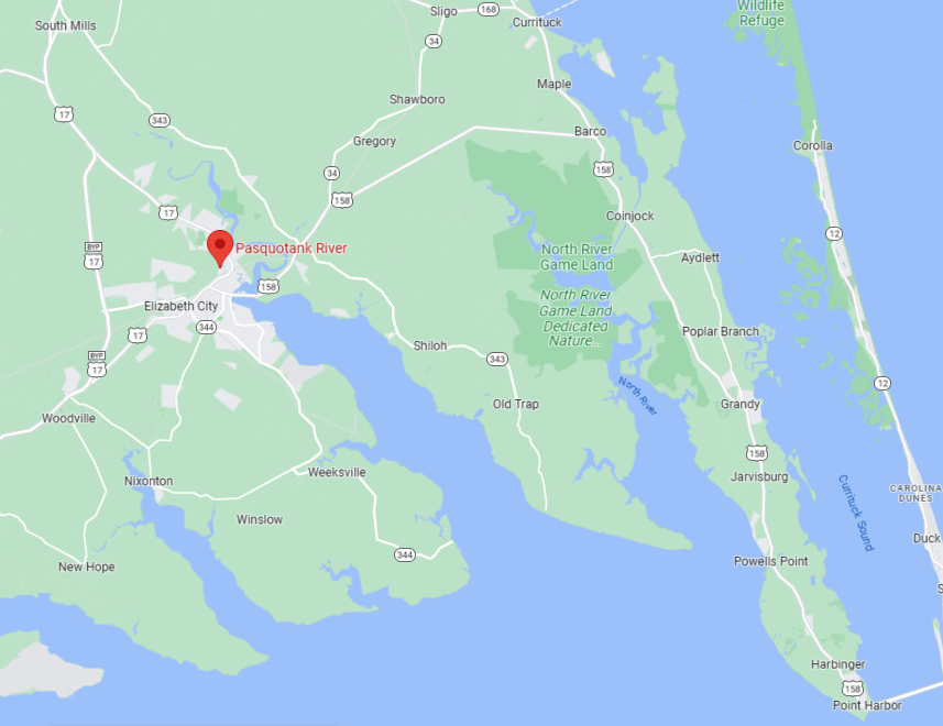
South of the North River, out in Albemarle Sound, boats doing a clockwise Carolina Loop cruise swing west around Camden Point and cruise up the Pasquotank River to the old port town of Elizabeth City. On the way up the river, on the west bank you'll see the U.S. Coast Guard Air Station, Elizabeth City. This base is the Command and Control Center for all Atlantic air—sea rescue operations from Greenland to the Azores to Barbados and the Caribbean, and it is home to many of the aircraft used in those operations.
The hulking rounded building near the Coast Guard Air Station is the Navy's old Blimp hangar. Today the hanger is the manufacturing facility for TCOM, L.P., the world's largest builder of lighter-than-air aircraft. The blimps flying over sports events and cities all over the country probably came from here, as did "Fat Albert," the DEA's tethered observation blimp often seen floating high over George Town, Great Exuma, in the Bahamas.
Elizabeth City, which calls itself "The Harbor of Hospitality," is approximately 19 miles up the Pasquotank River from its mouth on Albemarle Sound. It is on the mainland side of the tight 180°-degree bend where the river narrows and rounds Machelhe Island and passes under the Route 158 Bridge. Trading posts operated in the area as early as the mid-eighteenth century and the town of Redding was incorporated on the site in 1793. In 1801 the name was changed to Elizabeth City, possibly in honor of Elizabeth Tooley, a local tavern keeper who donated a substantial part of the land on which the town was founded.
From the 1805 opening of the Dismal Swamp Canal, the town prospered with an economy based on canal traffic (tolls), trans-shipping of cargos to and from canal boats, agriculture and timber. The 1859 opening of the Albemarle and Chesapeake Canal and the ravages of the Civil War nearly ruined the town, and it was not until the opening of the Elizabeth City & Norfolk Railroad (later the Norfolk Southern Railway) in 1881 that prosperity returned.
Today, Elizabeth City is the heart of a thriving agricultural area and a bedroom community for the sprawling Norfolk/Hampton Roads/Portsmouth military-industrial complex just to the north. The city welcomes transient cruisers with open arms to a restored waterfront and historic, walkable downtown full of shops, restaurants and things to see and do. Dockage on Mariners Wharf (the city docks) is free for 48 hours (no power or water but free Internet access).
Best of all, whenever a half dozen or more transient cruisers are on the docks, the Chamber of Commerce and local businesses continue the wine and cheese dock parties started many years ago by the original "Rose Buddies" welcoming crew. Children, young and old, will enjoy the nearby Museum of the Albemarle.
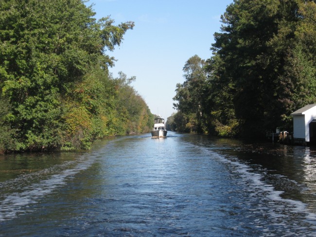
For the 20 miles upstream from Elizabeth City to South Mills, the South Mills Lock and the south end of the Dismal Swamp Canal, the winding Pasquotank River and Turners Cut is as pretty as any 20-mile stretch along the Atlantic ICW. Cypress and gum trees closely hem the river, backed by cedar, pines and mixed southern hardwoods. The trees, tall as they are, are second or third growth, by the Civil War loggers had nearly shaved the area. It was cut over again, less drastically, between the turn of the century and World War I and managed, selective, sustainable cutting continues today.
From late fall to early spring Bald Eagles are common in the Dismal Swamp, and in early spring to late fall Osprey are everywhere. Several species of Herons and Egrets are common year-round. The water is cypress swamp black water; it's not "black" from sewage or industrial waste, it is stained by the tannins in cypress bark, cypress leaves and other vegetation. In the days when coasting schooners loading timber and agricultural products made Elizabeth City a major port, the schooners water casks were often sent up the Pasquotank to be filled in the belief that the brown tannic acid-infused water kept better in the wooden casks than the water available in the city.
Turners Cut, which leads north to the South Mills Lock is the southern end of the Dismal Swamp Canal. Originally dug in 1856 to straighten a section that originally followed Joyce's Creek and the upper Pasquotank River, the Dismal Swamp Canal follows the original Turners Cut route almost exactly. From north to south, the canal begins on the Elizabeth River, at ICW mile 7.1, immediately south of the high I-64 Bridge. From the Elizabeth River, the canal runs through Deep Creek (and the short Deep Creek Land Cut) to the town of Deep Creek and the Deep Creek Lock before heading south for 21 miles to South Mills.
While it is possible to traverse the entire Dismal Swamp Canal route from Elizabeth City to Norfolk in one day, few cruisers seem to do so. Most opt for a slow, pleasant trip with a night between the locks on the dock at the North Carolina Visitors Center. The Visitors Center has clean restrooms, barbeque grills, picnic tables and a nice gift shop with the obligatory "I Did the Dismal" tee-shirts. There is also an associated Dismal Swamp Nature Center and Nature Trail. During the fall and spring snowbird migrations, boats are rafted four deep along the length of the Visitor Center's dock.
There is also bulkhead dockage inside the lock at South Mills (before you reach the Visitors Center), and there is a small public dock inside the Deep Creek Lock, from which it is a short walk into town. Since the last lock opening of the day is at 3:30 p.m., boats frequently anchor in Deep Creek, just north of the lock and only 10 miles from the attractions of Norfolk's Waterside and downtown Portsmouth…where the loop cruise started.
Contrary to general belief, George Washington had nothing to do with the Dismal Swamp Canal. He and a group of business associates owned approximately 50,000 acres of timber land in the Dismal Swamp where they built the "Washington Ditch" in order to float cut logs from their land out to the Elizabeth River. Scattered remains of this endeavor can still be seen in the Dismal Swamp.
Although it was the second of the two routes to be built, the Albemarle and Chesapeake Canal was the first to be authorized. Originally authorized in 1772 then reauthorized, re-reauthorized, re-re-reauthorized …. Between Virginia and North Carolina, the Chesapeake and Albemarle Canal was authorized no less than 10 times before construction actually began in 1855. When the canal opened in 1859 (completed in just four years by a small fleet of barge-mounted steam dredges), it was significantly wider and deeper than the Dismal Swamp Canal and was considered to be one of the engineering marvels of the century.
At the time, the original tide lock at Great Bridge, 220 feet long and 40 feet wide, was the second largest lock in the United States. The new canal quickly captured the bulk of the freight traffic between the Chesapeake Bay and Albemarle Sound. In 1913, acting on the 1910 River and Harbor Act plan to build a protected east coast waterway, the Federal Government bought the Albemarle and Chesapeake Canal and the Corps of Engineers set about enlarging it and giving it its present form.
A canal along the approximate route of the Dismal Swamp Canal was first proposed in 1728 by Colonel William Byrd II, but it was after the Revolutionary War before anything was done; Virginia authorized the canal in 1787 and North Carolina in 1790. The Dismal Swamp Canal Company began digging from both ends in 1793, with most of the work being done by slaves rented from nearby plantations. The canal causeway road, today part of U.S. Route 17, opened in 1804 and the canal opened the next year.
For several years after the canal opened, traffic was limited to canoes, rafts and flat boats because for the new canal had only a couple of feet of water for over half its length. Between 1812 and 1900 the canal underwent a series of improvements to widen and deepen it, but continuing problems with low water levels—problems that persist to this day—and competition from the Albemarle and Chesapeake Canal rendered the Dismal Swamp Canal economically unviable as a commercial concern.
In 1929 Congress purchased the canal from the nearly bankrupt Lake Drummond Canal and Water Company, the successor to the original Dismal Swamp Canal Company. In 1974 the Great Dismal Swamp National Wildlife Refuge was established, navigation on the canal was made secondary to water conservation and control and the little remaining commercial shipping was shifted to the Albemarle and Chesapeake Canal. The canal is now on the National Register of Historic Places, is maintained by the U.S. Army Corps of Engineers and is operated, water levels permitting, for pleasure boat and tourist traffic.