Crossing the Gulf Stream
Crossing the Gulf Stream is like traversing a wide, moving walkway–your boat is being steadily pushed northward. The longer you spend in the Gulf Stream, the farther north you will be unless you compensate for that movement.
Your best strategy is to take advantage of that push by starting as far south (or downstream) of your destination as possible. To the extent that it is possible, careful planning and navigation can minimize the time it takes to cross.
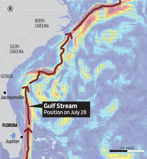
NOAA weather broadcasts give daily information about the Gulf Stream including its width, speed, distance offshore at different locations along the Florida coast and its temperature. Many online sources also give daily, detailed maps of the Gulf Stream.
For planning purposes a reasonable rule of thumb is to assume the entire distance you have to run from a Florida departure to a point lying along the W 79° 15.000' line of longitude will be subject to an average 2.5-knot, north-flowing current.
For faster boats this may have relatively little effect on your course and time to cross but for slower boats, particularly those under sail, the effect is profound and must be taken into account. There are essentially three ways to navigate this challenge:
- In the days before GPS and chartplotters, boats would compute a heading based on the average current and then steer that constant heading. The disadvantage to this approach is that it is based solely on averages while the actual current and wind will vary from day to day and during the crossing. But it generally gets the boat close enough to your destination that it can be recognized.
- The boat can be steered to stay pointed at the destination waypoint. This works but is not the most efficient method and will take more time.
- For boats equipped with GPS, a chartplotter and preferably autopilot, steer to constantly keep the boat on the route from starting point to destination. The actual heading will vary constantly. You will need to adjust to the actual current and wind drift as you move along the route. This is the most efficient way to navigate the crossing.
There are as many opinions on when to depart Florida and at what time to arrive at your Bahamian waypoint as there are vessels crossing the Gulf Stream. Night crossings are common but they do present the additional challenge of traveling amidst the ever-growing number of freighters and cruise ships in very busy shipping lanes to and from Florida.
Dawn departures provide easier travel in the shipping lanes and arrival in Bahamian waters with the sun behind you. And if you decide to continue across the Banks, night passage will be in many ways easier there than in the Gulf Stream.
You should consider your speed of travel, destination and what conditions are expected when you arrive. A vessel departing for and planning to visit North Bimini will have a much different crossing schedule than one headed non-stop to Nassau. Regardless, pay attention to the weather and don't develop forward-only vision.
Be vigilant about frequent checks for other vessels to starboard, port and aft! Don't become another victim rundown by an inattentive skipper traveling on autopilot. And don't forget to file a Float Plan. (A number of free iOS and Android apps allow you to create a float plan and email it to participants or emergency contacts.)
The Constant Heading Table
If you choose the constant heading approach to your passage, the Magnetic Heading & Time-to-Cross table provides for a given boat speed, the single heading to steer and the time to cross on that heading.
This data will always be an approximation but is a good estimate for your constant heading and also a good tool for planning passage time if you will be steering to stay on a route line.
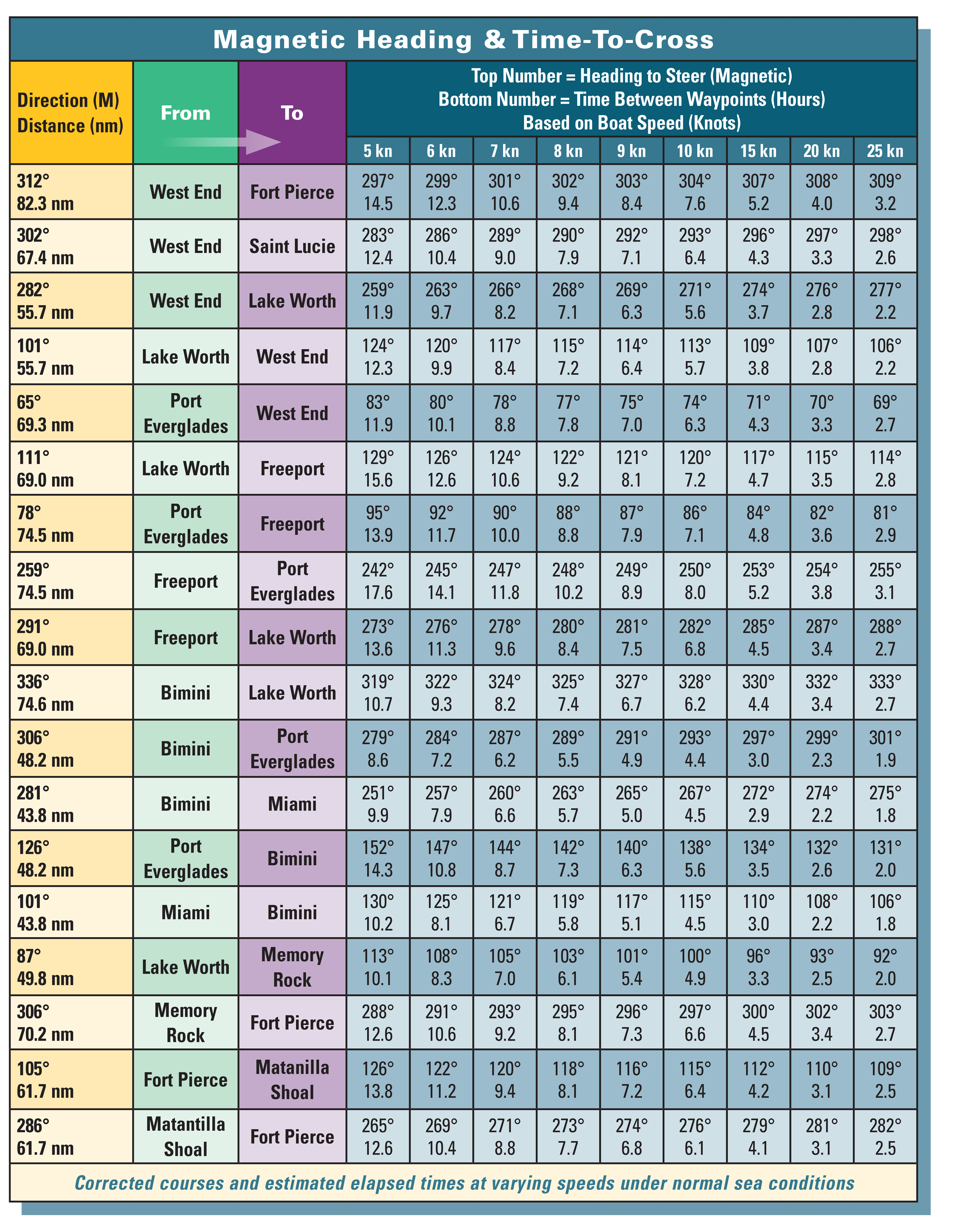
The tables are based on the WGS84 datum and 2019 magnetic variation from the National Centers for Environmental Data at NOAA. The results are accurate to within 1° True.
The current was assumed to be the average current in the Gulf Stream, which is 2.5 knots. They do not consider wind drift or leeway; compensating for these for your vessel will improve accuracy.
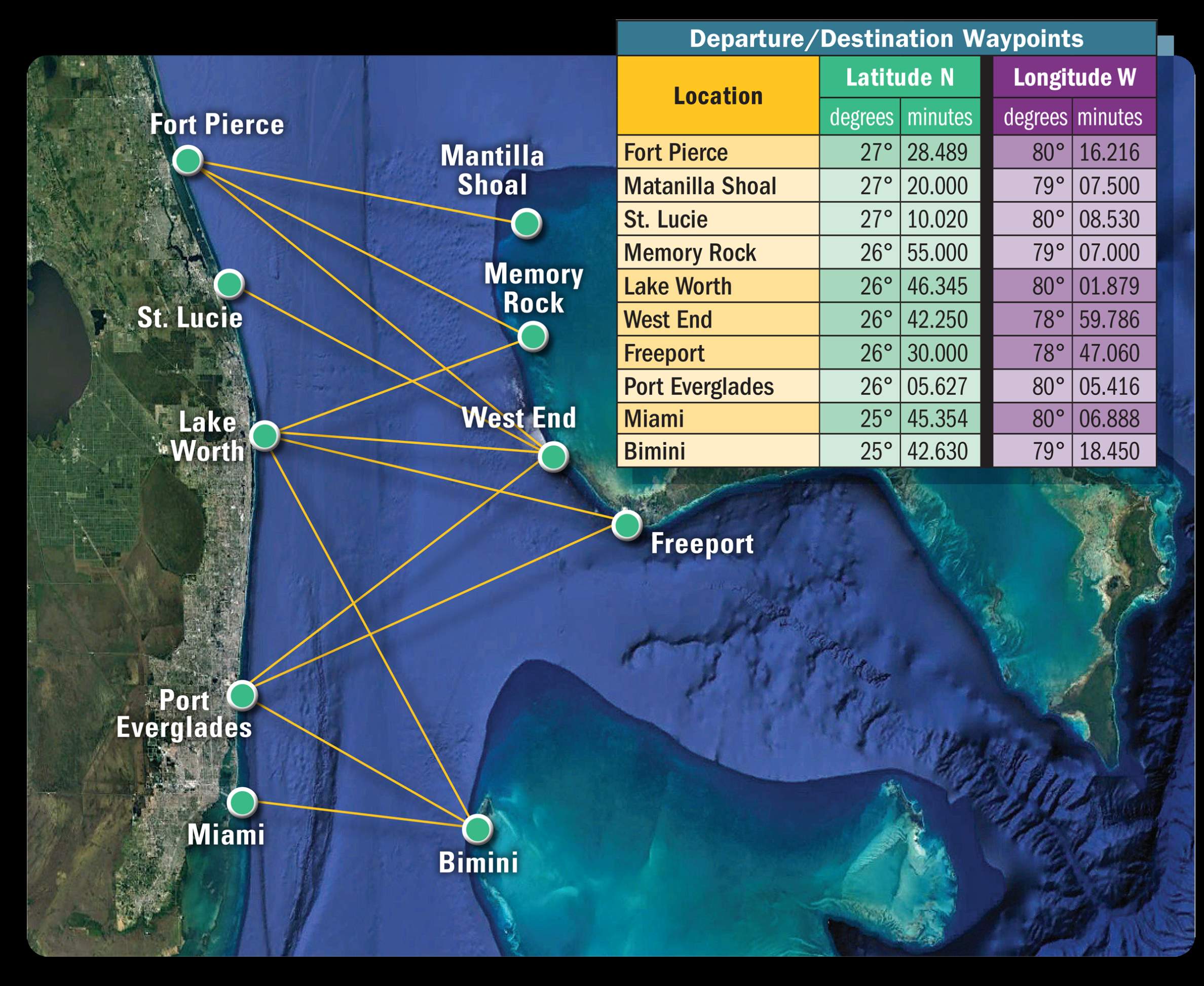
The from/to locations correspond to the waypoints identified in the Departure/Destination Waypoints table. They can be used regardless of your destination but you will have to adjust your total trip plan for additional distances to be run.
For example, assume you want to leave from Lake Worth (Palm Beach) Inlet and go to West End. The fourth entry in the table shows the distance traveled between these waypoints is 55.7 nm at a bearing of 101° magnetic. Also assume you plan to travel at 8 knots boat speed.
The table shows that at 8 knots you must steer on average 115° magnetic to arrive near the destination waypoint. The time en route will be approximately 7.2 hours between the two waypoints.
So if you plan to leave your anchorage or slip early and arrive at the departure waypoint at 7:00 a.m., you should arrive at the destination waypoint at approximately 2:12 p.m. Of course, you need to allow for the time required to get from there to your final overnight stop wherever that may be.
Remember that if you use GPS and remain on the route line between points your heading will vary with the current and wind conditions but you will average 115° magnetic over that time. On the other hand, if you steer a constant 115° magnetic, you will deviate from the route line but should end up at or near the destination.