GNSS Jamming & Spoofing: What Skippers Need to Know Now
Modern boating runs on satellite Positioning, Navigation and Timing (PNT). Chartplotters, AIS time stamps, radar overlays, and autopilots all assume that GNSS—GPS, Galileo, GLONASS, BeiDou—will deliver a clean, continuous fix. Increasingly, that assumption gets tested. The Nautical Institute has devoted a full Navigator package to the subject, and this article distills their guidance into a single narrative for recreational skippers. All of the material below comes from articles printed by The Nautical Institute; individual authors are acknowledged at the end.
What’s Actually Happening Out There
Two kinds of interference are driving most of the incidents. Jamming simply drowns out the very weak satellite signals with stronger radio energy near GNSS frequencies. Receivers can’t lock on, alarms fire, position freezes or drops to dead reckoning, overlays vanish, and anything that depends on a live fix either reverts or fails. Spoofing is more insidious: instead of silence, the receiver hears a convincing lie—a false signal that makes your position, course, and speed look plausible while they drift away from the truth. In other words, jamming makes your electronics die; spoofing makes them lie.
These disruptions are not theoretical. They occur naturally during solar storms and ionospheric disturbances, but they also arise from deliberate human activity—from low-power “privacy jammers” to high-power sources that affect wide areas. Certain regions experience clusters of interference, and integrated bridges can cascade errors quickly: the chart looks good, the autopilot steers the magenta line, AIS targets paint neatly—until a lookout notices the shoreline on radar isn’t where the plotter says it should be.
How it Looks from the Helm
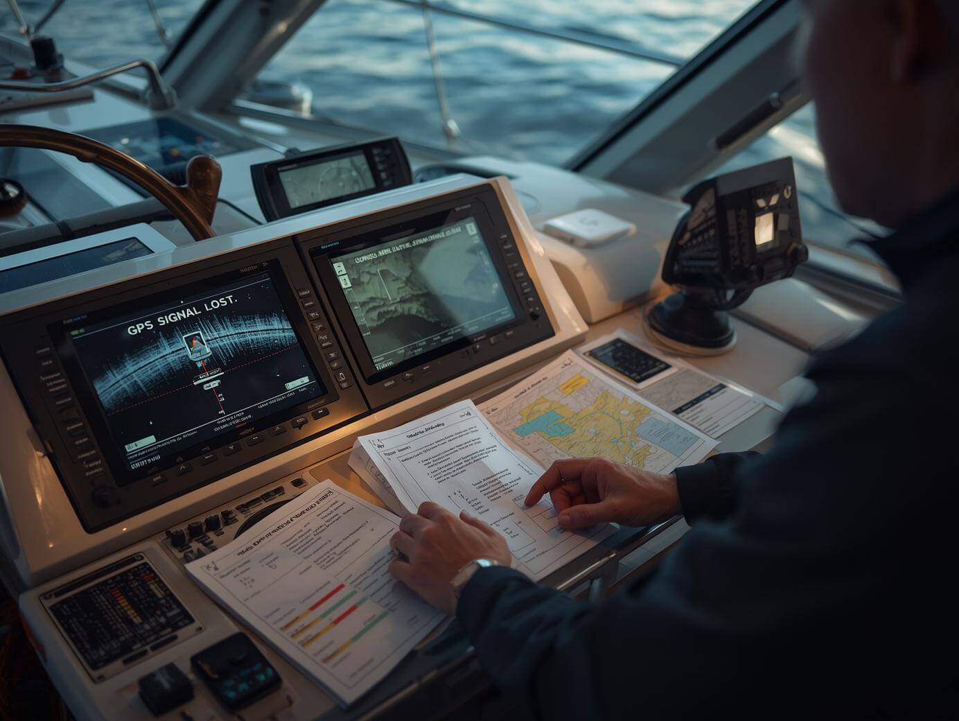
When jamming hits, the symptoms tend to be obvious. You’ll see “no fix” messages, “position lost,” or sensor-fail alarms. The chart stops following your movement or begins to drift on a guessed track. Radar overlay disappears. The autopilot may kick to standby or hunt for a track it can’t reliably follow.
Spoofing, by contrast, hides in plain sight. The screen appears normal, the COG and SOG seem reasonable, and the track line is comfortingly tidy. Yet the vessel slides off reality—perhaps a degree at a time—until you notice the set and drift do not match the wake, the echo sounder disagrees with the depth contours, or the radar coastline doesn’t align with the charted shoreline. Some receivers expose warning signs—degraded integrity checks, poor dilution of precision, odd signal-to-noise behavior—but many helm setups don’t surface those details clearly. This is why traditional seamanship remains the best early-warning system afloat.
What Good Seamanship Looks Like in the GNSS Era
The Nautical Institute returns to a simple rule: never rely on a single source of position. GNSS is one modality—powerful, convenient, and fragile. Skippers who habitually corroborate GNSS with independent references almost always spot the lie early.
In practice that means maintaining a gentle rhythm of cross-checks appropriate to the waters. In open water, a periodic visual or radar fix—logged against a dead-reckoning or estimated-position plot—confirms you’re broadly where you think you are. As the water narrows, that rhythm tightens. Radar ranges and bearings to fixed objects, parallel indexing along a channel edge, echo-sounder comparisons with charted depths, and hand-bearing compass lines to conspicuous marks are all fast, reliable, non-satellite checks. When those references and the plotter disagree, treat the GNSS picture as suspect until proven otherwise.
It also means planning as if you might lose GNSS where it’s most inconvenient. Before departure, identify the constricted sections—bars, inlets, bridge transits, fairways, tight turns—and prepare non-GNSS ways to run them. Pre-build radar parallel indexes for the channel edges or turn points. Note conspicuous marks whose ranges and bearings give quick fixes. Keep paper or at least printable approaches for the choke points, and make sure everyone on watch knows how to drive the boat when the magenta line disappears.
When the Alerts Cascade
Many crews discover during the first event that multiple alarms can overwhelm attention. The safest response is disciplined triage and role clarity. Someone has the conn and the lookout; someone else works the navigation picture with radar and visuals; someone manages alerts and communications. Silence the non-critical alarms quickly, so they don’t mask the ones that matter. Reduce speed to buy time. If the picture remains uncertain, hold safe water or anchor and reset situational awareness with independent fixes. The right call in restricted visibility may be to stop, wait for assistance, or divert rather than nurse a doubtful track through a narrow pass.
Autopilots and Overlays Are Helpers, Not Leaders
Modern systems encourage us to let the electronics “lead” the navigation picture. The better approach—especially when interference is possible—is to demote the GNSS stream from master to contributor. Know how to remove GNSS input from the chart overlay and from the autopilot when confidence is low. Be comfortable steering by compass against radar parallel indexes and visual ranges. Make it possible to navigate cleanly even when the plotter becomes little more than a background chart.
If you can, add diversity. A second GNSS receiver on a different antenna and from a different manufacturer improves resilience—particularly if both units expose integrity warnings. Better still, treat terrestrial references (radar and visual) as your independent cross-check, not as decorations layered on a satellite-led picture.
Training That Actually Sticks
The most useful drills are short and realistic. Run a “GNSS lost at the inlet” scenario on a clear day with space to spare. Practice disabling overlays, hand-plotting radar ranges and bearings, updating DR/EP on the screen, and steering the boat by compass along pre-planned indexes. Run a “spoofed but looks normal” drill, where one watchstander quietly offsets the plotter and the team must detect the discrepancy using radar and visuals. These repetitions convert abstract advice into muscle memory, and they reveal gaps—menus you don’t know, bearings you can’t take from the helm, or reference marks you didn’t pre-select while in harbor.
Equally valuable is a short pre-departure brief that treats interference like weather: where it’s likeliest, what signs we’ll watch for, who does what if it happens, and where we can safely wait it out. If you cruise in regions with frequent disruptions, fold the latest advisories and manufacturer bulletins into that brief so the team knows what to expect.
A Realistic “Immediate Actions” Mindset
When the position picture becomes unreliable, think like an engineer and a mariner at the same time. First, stabilize the system: slow down, reduce alarms, and drop dependencies on GNSS—no overlay, no GNSS-steered autopilot—until you re-establish truth. Second, rebuild situational awareness from independent observations: a couple of clean radar or visual fixes, an updated DR/EP, and a quick comparison to echo-sounder depth will usually settle the question. Only then decide whether to proceed, divert, or stop. The order matters. Acting on a false picture is how benign interference becomes a grounding report.
The Part That’s Easy to Forget
All of this is far less dramatic than it sounds. Mariners crossed oceans for centuries without satellites. The seamanship that made that possible—looking out the window, understanding the water and the land, measuring with simple instruments, writing numbers down—remains the antidote to modern interference. The Nautical Institute’s real point isn’t to alarm anyone; it’s to remind skippers that GNSS is a brilliant servant and a poor master. If you train, plan, and navigate accordingly, jamming and spoofing become manageable nuisances, not show-stoppers.
Acknowledgements
All material in this article is condensed from pieces printed by The Nautical Institute. We gratefully acknowledge the authors and contributors of the Navigator package on GNSS interference:
- "NavBrief” by David Patraiko FNI, Director of Projects, The Nautical Institute.
- "GNSS jamming: What every mariner needs to know” by Rear Admiral Tim Henry OBE AFNI.
- "Taking action: Dealing with disruption – and coping with compromise” by the Gard P&I Club (Navigator package contributor).
- "WAYPOINT – Staying alert to jamming and spoofing” by George Shaw, Royal Institute of Navigation.
- "Take 10 #40: Managing GNSS” compiled by The Navigator team at The Nautical Institute.