i911 Helping Coast Guard Save Lives
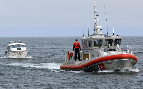
Command center personnel and rescue crews in the United States Coast Guard have a new tool that helps them find a stranded or distressed vessel even more quickly. Known as i911, the program lets Coast Guard staff use a mariner’s cell-phone number to locate a boat.
New Technology
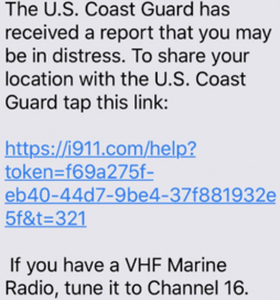
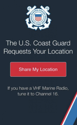
Once the number is entered, the mariner receives a text message authorizing him to share his location with the Coast Guard. When the information is shared, the cell phone’s internal GPS, which uses satellites to pinpoint the mariner’s location, is displayed on a screen for watchstanders to aid in the search.
The software was developed by Callyo Inc., a firm that specializes in mobile technology for law enforcement and is a free service for all first responders, including the Coast Guard.
“What’s cool about my job is that I get to learn about new technology, and how we can apply it to help the Coast Guard,” said Lt. Anne Newton, Coast Guard Research and Development Center. “The second I saw Callyo’s presentation, I knew this would help command centers tremendously.”
Real Challenges
Newton worked in a several command centers before her time at the R&D Center and understands the struggle command center crews face when trying to find someone they know is counting on the Coast Guard to bring them home.
Depending on the cell-phone service, i911 can determine locations of distressed mariners from up to 20 nautical miles offshore. During the pilot period from May to November 2019, more than 38,000 search and rescue cases across the contiguous United States were analyzed, and 89 percent of them took place within 20 nautical miles offshore.
Coast Guard Sector Long Island Sound, located in New Haven, Conn., was the first to test the system. After a successful trial, all five command centers in the Coast Guard’s First District Sector that range from Maine to northern New Jersey began their own tests. As of early March, i911 was made available to all Coast Guard stations.
Participation Required
It’s not a perfect system though. The biggest challenge watchstanders at Sector Long Island Sound had was teaching distressed mariners how to turn on their location services. The i911 system will not work without it.
“It’s really cool technology and already helped us on numerous occasions with search and rescue,” said Joshua Olsen, a command duty watchstander for Sector Long Island Sound. “Sometimes, we just need to talk people through how to share their location.”
During the pilot period, the i911 system assisted in bringing home several mariners including three people on an inflatable raft. They were blown out to sea by high winds and strong currents and couldn’t paddle to shore. The trio had only its cell phones and i911 pinpointed its location about 6 miles offshore where rescue crews found them and brought them home safety.
Chief Petty Officer Andrew Case, a command duty officer at Sector Southeastern New England in Woods Hole, Mass., liked having this tool to use for search and rescue.
“It’s like Rescue 21 for the phone,” said Case. “It greatly decreases the time we spend looking for someone and gets the rescue crews out faster.”
Case also said that doesn’t mean mariners should not have a VHF radio on board. The most reliable and traditional means of communication for mariners to use when in distress is VHF channel 16.