ICW Navigation Requires New Skills for Many Mariners
Perhaps you are an experienced mariner in Maine, Long Island Sound, coastal sailing, or even crossing oceans. You've referenced chart plotters with various charts displayed, perhaps PC programs like OpenCPN, and your favorite tablet mobile app (e.g., Navionics) along with aids to navigation (ATONs) as you proceed along your planned route.
You've learned to "read the water" for depths in the Bahamas or Keys and pay close attention to depth changes as you proceed. You plan on applying the same skills in navigating the ICW – what more is needed?
The ICW presents some challenges to traditional navigation not routinely encountered elsewhere. Here are some differences when transiting the ICW, with examples and navigational resources useful for avoiding a grounding, or worse, prop damage.
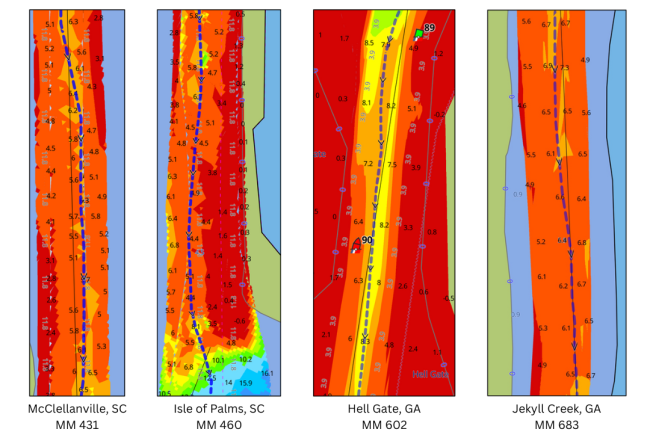
The charts include data from the U.S. Army Corps of Engineers (USACE) as displayed in Aqua Map. The blue dotted line is the Bob423 track, available for free download in GPX format.
The ICW is Shallow
You may take a passage through a shoal area with less than a foot of clearance for your draft. Those familiar with boating the Bahamas may feel right at home but others may feel stressed. I know I did when I first went down from New York to Key West.
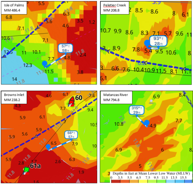
The numbers are the depth in feet at Mean Lower Low Water (MLLW). The shallow areas are often also very narrow. You must pay close attention to staying on track by back sighting your movement in the channel and making sure you are properly aligned and not drifting.
In the examples above, the usual strategy is to wait for mid to high tide if your keel is deeper than the water at low tide.
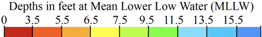
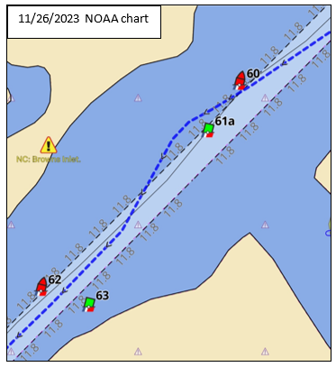
The ICW can shoal over the course of weeks, sometimes faster. NOAA charts cannot keep up and do not show depths where there's frequent shoaling, leaving such areas blank. Even when showing depths, the NOAA charts cannot always be depended upon to locate the deepest water through shoaling areas. Browns Inlet is shown.
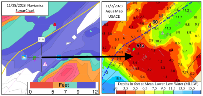
Good news. The US Army Corps of Engineers periodically surveys the ICW and uploads the data to the eHydro database. Aqua Map downloads those surveys and displays them as overlays on their charts as seen below. The four snapshots of a famous shoaling area, Browns Inlet at MM 238 in North Carolina, illustrate how rapidly the ICW can change.
Note the movement of G61A by the U.S. Coast Guard as shoaling progressed, which looks good, but the relocation of G61A typically lags the shoal extending beyond G61A by a week or longer. I'll cover that problem later in the article.
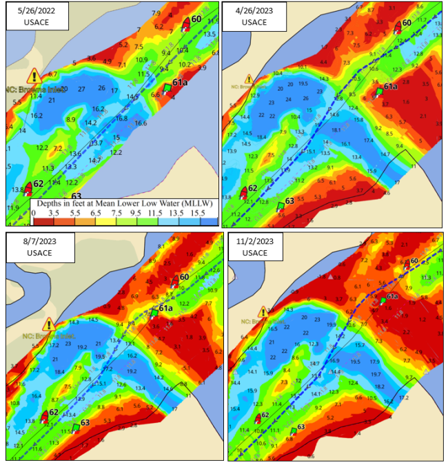
The USACE is certainly a good resource but how about other charts, such as NOAA's charts and a popular app such as Navionics SonarChart which updates charts to within 1 foot from boaters' uploads of sounding data? Navionics publicizes "up to 5,000 updates every day." Note the date of the charts in the upper left corners.
The arrow points from the 11 MLLW depth shown in Navionics SonarChart to the actual 1.7 MLLW depth as surveyed by the USACE at the same spot. According to Navionics, there's no need to honor the green ATON, there's 11 MLLW down the middle of the channel. We know that's wrong from looking at the USACE chart and from the many boaters who have gone aground there in the last few months of 2023.
The NOAA official chart is of no use. It shows only the original ICW dredge depth of 12 feet. NOAA does not adjust depths for shoaling at Browns Inlet or for other rapidly shoaling areas.
These examples reinforce that planning your trip through the trouble areas of the ICW should include referencing the Waterway Guide Navigation Alerts and Aqua Map. The team updates the information as it becomes available from many sources. The Alerts are available in Aqua Map and from the Waterway Guide's Explorer portal. See the alert symbol and select it to open a complete description and important links that are date stamped.
Aqua Map mobile navigation app, its online chart viewer, and Aqua Map in Waterway Guide's online Explorer portal all display the USACE surveys. All three platforms show the same information, in the same format, as all are served from the same source at the same time.
More than just a viewer, the surveys seen in the mobile navigation app offer more chart details and information. Aqua Map for Apple and Android devices is only $30/year. No other app, PC program, or chartplotter has implemented USACE surveys in their products.
The depths can change in a boat length in the channel. Near inlets, sand can build up in banks with steep sides, giving no warning of shallow water until you impact the sand or mud with your keel or prop.
All of the examples above are as of 11/29/2023 and are located in the NOAA official ICW channel. You can see that the blue dotted line avoids them but if you're just following a NOAA chart, you have very little warning before grounding at low tide if you're trusting your sounder to warn you of shallow water ahead. The NOAA charts of the same areas all show 12 MLLW with no depth readings in the channel.
The bottom makes a difference in boat damage. Sand, like at Isle of Palms and Browns, is unforgiving and can quickly damage exposed props. Mud, on the other hand, is a bit more forgiving like at Peletier Creek and on the Matanzas River.
If you have Aqua Map with USACE surveys at the helm, you can identify shallow water and take action to avoid grounding. There are free tracks that can be downloaded at this link: Bob423 track. Updated throughout the year, the shoal areas are also listed as a Waterway Guide Alert, which can also be accessed in Aqua Map at each Alert icon or through the Waterway Guide Explorer web portal.
NOAA charts can be off in Lat/Lon. The charts are much better than they used to be several years ago but errors still exist that have led to groundings. Eric was following his Garmin chartplotter heading towards Coinjock last spring. He was surprised when he came to a sudden halt – he was in the middle of the channel – how could this be?
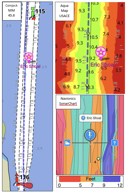
Look at the USACE survey for that location.
NOAA charts used by Garmin (and all chartplotters) are offset in this area. Eric was actually on the side of the channel and found shallow water.
In the USACE charts, every depth sounding is referenced to a GPS coordinate. There's no stretching or moving of a chart datum to match up with a coordinate system.
Navionics SonarChart has a similar system although it depends upon the boat's GPS and not the centimeter accuracy of a USACE survey. Let's see how it fared.
Navionics SonarChart also shows the correct location of the channel and where Eric grounded in a shoal on one side of the channel.
While we have the SonarChart shown, take note of the right side of the chart. It shows 9 to 12 MLLW when there's only 3 to 4 feet. Navionics SonarCharts uses the NOAA chart as a starting point for depths and then updates the soundings with boater uploads. The original ICW channel was dredged to 12 feet but it shoaled over the years before Navionics started collecting boaters' soundings.
Since it's 3 to 4 feet over there, no boaters reached the area to send new soundings to Navionics. Without new data, Navionics kept the original NOAA depths. Rest assured, there's no secret 12-foot channel over to the right on the chart. This phenomenon can be seen along the edges in many areas covered by the Navionics SonarChart technology.
NOAA charts have improved dramatically in the last five years relative to Lat/Lon offsets. I only know of one other area with an offset and it's not on the ICW. It's the anchorage area at Steamboat Creek in South Carolina. Other than that, and the example shown, the NOAA charts match the output of your GPS receiver. Another option is to load the Bob423 track to your chartplotter or app so you will have a running reference to the deepest water path. The GPX format is universal for navigation programs.
ATONs can lead you into a shoal. Just honoring the ATONs will not always prevent a grounding and in many shoal areas the ATONs are few and far between. It can be tough keeping on track with side currents at inlets.
Browns Inlet is shown at MM 238 in North Carolina before G61A was relocated several weeks later. Shoaling progressed faster than the Coast Guard could move G61A. If you were unaware of the shoaling, you could run directly into a 3-foot shoal at low tide by splitting R60 and G61A.
I received a call from the dockmaster at Harbour Village just south of Browns Inlet on eight powerboats that came into his marina for prop repairs over three weeks. They split the buoys and ran directly into a shoal – and it's sand, not forgiving mud.
Costs for twin prop boats that grounded at Browns Inlet this year ran to a minimum of $2500 per incident on average but only if the props were the only thing damaged. (short-haul, labor for removing and replacing props, assuming you have spare props on hand, repair, and retuning of damaged props later, etc.). Referencing the latest resources, including Aqua Map, Waterway Guide, and verified boater experiences will save time and money.
G61A was later moved to the edge of the shoal but then the shoal continued to creep into the channel and boats still ran aground.
I used the example of Browns Inlet to show where a buoy can lead you astray. The U.S. Coast Guard does a pretty good job and situations like these are rare, but they do occur.
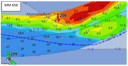
One final example is at MM 658 which catches a few every year. Boaters that run into trouble are in the channel and honor R208 but pass too close and run into a shoal near low tide. I pass by in 25 feet of water on the Bob423 track.
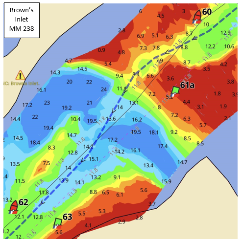
Navionics SonarChart cannot keep up with rapid shoaling. Navionics SonarChart produces contour charts in one-foot increments corrected to low tide (MLLW) based on uploads from boaters' soundings. It's a great service for boaters and I always have both Aqua Map and Navionics SonarChart running at the helm when I'm on the ICW. However, you need to be aware of the limitations of SonarChart when operating in the rapid shoaling areas of the ICW.
Since their charts depend upon uploads from boaters, the charts have two limitations:
- They only show depths where boaters go.
- SonarCharts lag the actual depths when shoaling is rapid. Here are a few examples:
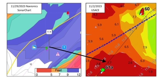
The example is at Browns Inlet where many boats ran aground. The yellow line in Navionics SonarChart and the dotted line in Aqua Map showing USACE are the same track. If you used Navionics SonarChart for navigation, it would show 11 feet of water at low tide where there're only 1 to 2 feet per the USACE survey, attested to by the many boats that crashed into the sand shoal. The shoaling occurred too rapidly for Navionics SonarChart to keep up. Once shoaled, no boats crossed the shoal (they couldn't) to send updated soundings to Navionics.
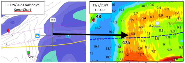
The second example is Lockwoods Folly, another rapid shoaling area. Navionics SonarChart shows 11 feet of water at low tide where there is only 6.3 feet (MLLW). The area is shoaling too rapidly for SonarChart to keep up. There are more areas with examples, but they all tell the same story – in rapid shoaling areas, do not depend upon Navionics SonarChart to show the true depths. I restrict my use of SonarChart to areas that shoal gradually, which is 99% of the ICW. It's a good resource for the vast majority of the ICW but it can lead you astray in certain areas, be aware.
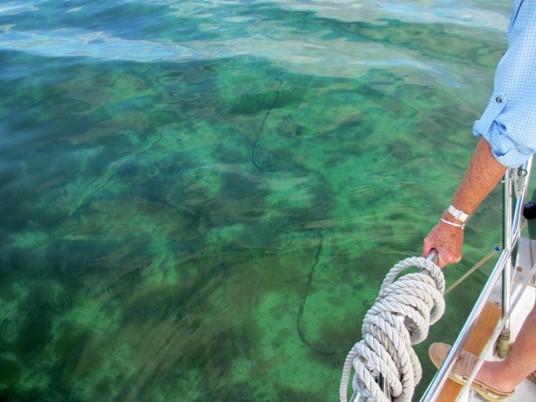
ICW waters are not transparent and it's very difficult to "read the water" for depth. That technique works well for the Bahamas and the Keys but not for the murky waters of the ICW.
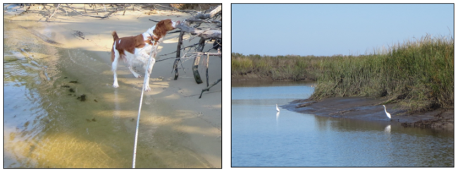
The tannin from decaying trees, leaves, and branches colors much of the ICW, making the water impenetrable to visually "reading the water" for shallows as shown in the photo at upper left. In areas without tannin, fine particulate mud takes over like in Mud River pictured above right. I've never been successful in looking at the water to determine its depth except in the Keys where the water is impacted by the Gulf Stream as shown below.
But can you get hints of the depth by looking at the ripples around a shoal? It's possible but that depends on which side of the shoal has the current. At Browns Inlet, the current was flowing parallel to the shoal and didn't disturb the water very much, so it depends.
In the Keys, we're back to the clear waters we enjoyed in the Bahamas or the Caribbean and even parts of Maine. You can see the bottom at Rodriguez Key in the Hawk Channel in 10 feet of water. Our chain is lying on the seabed.
Summary and Recommendations
Tried and true navigation skills certainly apply in the ICW. But they don't work 100% of the time - more like 99% of the time. It's that 1% that you need to be vigilant about if you have exposed props and want to avoid expensive repairs and delays. If you're in a boat with a keel that protects the prop, the downside is much less but still an inconvenience at best. Sit back a moment and take stock. Should you invest in the new skill of learning to use Waterway Guide resources and the Aqua Map mobile navigation app?
For the ICW, probably so. As a top-flight navigation app with the USACE surveys included – it's a virtual necessity if you're serious about avoiding groundings on the ICW. Aside from Aqua Map, navigating the shallow waters of the ICW can be less stressful with the skills learned by using new tools. I list a few below starting with Aqua Map:
Aqua Map with the USACE surveys should be number one on your list. Only Aqua Map displays the USACE surveys ready for navigation, no other app or PC program does. It comes with features too numerous to mention in this short article. Routing, AIS, Route Explorer, Marine Forecasts, Anchor Alarms, WiFi connection to a Gateway, Waterway Guide points of interest, Tides and Currents, Satellite Overlays, and much more. See the Aqua Map app overview for full details. And there are tutorials and guidance embedded in the app and on their website.
Waterway Guide offers a wide range of publications. A subscription to the online offerings, the mobile app, and the guidebook of your choice is inexpensive and thorough. Navigation Alerts, Marinas, Anchorages, Moorings, Bridge and Lock schedules and details, Service Facilities, and Fuel locations and prices are included in all the digital and printed publications. The books are updated annually and spiral bound softcover, and in the digital formats can be downloaded to your phone or tablet in either the Apple or Android app. See the Waterway Guide Store for a complete listing of resources available to the cruising sailor. Highlights include:
- Ten Guide books, updated yearly, covering from the Great Lakes to the Keys and Cuba in spiral-bound paperback and digital format. Access Boating Destinations for more details.
- Explorer is the online chart viewer and planning resource from Waterway Guide Media that features Aqua Map USACE surveys and charts for viewing, measuring tools, thousands of navigation points of interest, and maps.
- The Waterway Guide App allows access to all the digital versions of the guidebooks. Once downloaded, you do not need an internet connection to reference all the available content.
- The Knowledge Center provides a wide range of current information for cruising mariners.
The Bob423 ICW Cruising Guide is published yearly with 2023 being the current edition. The 296-page Guide covers basic knowledge needed for those transiting the Atlantic Intracoastal Waterway (ICW) and the ICW University series starts with more detailed explanations of nautical knowledge needed for navigating the ICW. The final 126 pages cover the status of ICW shoaling with full-color charts and how to safely navigate the hazards. The Guide is available in paperback, hardcover, Kindle eBook, and from Waterway Guide as a digital edition in the mobile app, which allows updating throughout the year as the ICW changes. All versions are described with links in the 2023 ICW Cruising Guide.
Bob423 Tracks are the blue dotted lines in the screenshots of charts in this article. They are available at no charge in GPX format, suitable for loading into Aqua Map, Navionics, and any chartplotter accepting the GPX file format. I haven't found an app, PC navigation program, or chartplotter that didn't accept them. They are a great resource for planning your trip and can be found at the Bob423 Download site. In the site header, you'll see numerous help pages on how to download the track, videos on how to use Aqua Map and other useful tools. The Bob423 tracks are updated throughout the year as conditions on the ICW change.
ICW Cruising Guide Facebook page has 20,000 members devoted just to navigational issues on the Atlantic ICW. If someone sees a problem, it's highlighted here first. Join the group and keep abreast of shoaling on the ICW.
Atlantic ICW Chartbook is for those who just want charts of the ICW in 5-mile increments from Norfolk, VA to Miami, FL. The format is the familiar NOAA paper chart style you've used for years. NOAA will be ending this format in the next few years. Get your copy now.
Enjoy your time on the ICW and say hello as you pass by. See you out there…
Bob423
Contributing Editor