Navigating Biscayne Bay
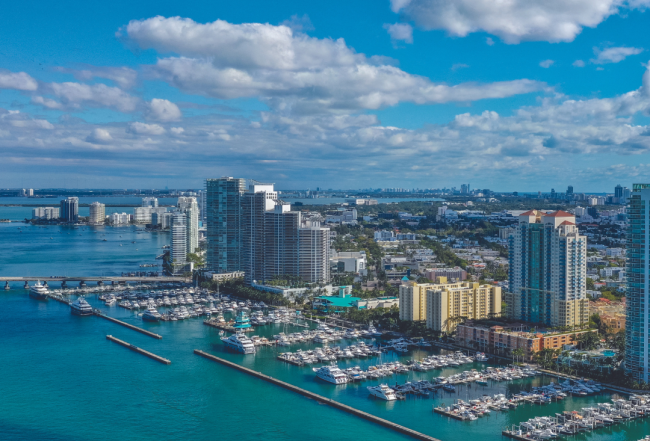
At 35 miles long and up to 8 miles wide Biscayne Bay ranks as one of North America's great inland waters. Over it's great size the bay also undergoes great variation of scenery, color and development. While not shown on charts, the bay is generally divided into three distinct segments: North, Central and South.
North Biscayne Bay stretches from Bakers Haulover (North Miami Beach) Inlet to Government Cut (Miami) Inlet, the main entrance to the Port of Miami. This segment starts very narrow adjacent to North Miami and gradually widens as it fills the gap between Miami Beach's barrier islands and the mainland. The appearance changes as well. The murky green water and mud bottom of its upper reaches gradually change to a turquoise color with a sandy bottom farther south, just as low-rise development gives way to high-rise on its shores. This segment provides access to Miami Beach, which is a worthy side trip.
Starting south of Dodge Island, Central Biscayne Bay is a boater's paradise. From here south to Cutter Bank, the bay's central segment is wider and its beautiful turquoise waters are deeper. The breadth of the bay here provides boats with room to maneuver but it's barrier islands still create excellent protected anchorages. The high-rise development that flanked the lower reaches of the north segment slowly give way to wilderness and parkland as you enter Biscayne National Park. This land and sea reserve is a treasure and well worth a stop for a walk or snorkel.


North Biscayne Bay–ICW Mile 1080 to Mile 1090
The ICW enters the north end of Biscayne Bay at Bakers Haulover (North Miami Beach) Inlet. The area generally referred to as "North Biscayne Bay" stretches from here to Miami's main inlet, Government Cut (Miami) Inlet. As the bay deepens a variety of routes weave past and amongst the man-made causeways and islands. Cruisers can opt to stay in the ICW closer to Miami or leave the ICW via any of several routes for a side trip to explore Miami Beach.
Greater Miami bustles with activity on land and water. The north segment of Biscayne Bay is particularly busy and with its heavy boat traffic, numerous islands and shallow pockets of water, it can be confusing to navigate. Study your charts carefully before attempting to transit this sometimes confusing area.
NAVIGATION: Use NOAA Chart 11467.
South from Bakers Haulover (North Miami Beach) Inlet, the ICW maintains a straight course as it angles diagonally across North Biscayne Bay, reaching the western shore just before the West 79th Street Bridge. The narrow but well-marked channel parallels the eastern shore until it passes Broad Causeway Bridge with 16-foot closed vertical clearance. This is the first of five restricted Miami spans. The span opens on signal except from 8:00 a.m. and 6:00 p.m. when the draw need only open on the quarter hour and three-quarter hour (year-round).
Continuing south from Broad Causeway follow your chart carefully. Starting from green daybeacon "17" there are numerous hazards just outside the marked channel. At flashing red "26" the ICW channel changes course and heads for West 79th Street Bridge at Mile 1084.6 (25-foot closed vertical clearance). The bridge opens on signal, except Monday through Friday (except Federal holidays) from 7:00 a.m. to 7:00 p.m., when the draw need only open on the hour and half hour. Be sure to indicate that you want the "western" span when calling the bridge on VHF Channel 09, rather than the East 79th Street Bridge span for the Miami Beach Channel.
If your intention is to "diverge" from the ICW to explore Miami Beach, you should exit the marked ICW channel just past green daybeacon "15" turning southeast toward Normandy Isle. The relatively well-marked Miami Beach Channel route is described in detail below.
Just south of the West 79th Street Bridge on the western shore is the marked entrance to Little River, which has facilities with various services for transients. South of Little River, the ICW–now narrow and surrounded by shoals–continues on a relatively straight course to the Julia Tuttle Causeway Bridge.

South from the Julia Tuttle Causeway Bridge the water outside the channel is slightly deeper but still too shallow for most cruising vessels. Take a moment to consult the charts before approaching the next series of closely packed bridges and channels. The short stretch from Mile 1088.5 to Mile 1089.5 is one of the most complex along the ICW. Over the 1-mile stretch you will pass four bridges, cross the turning basin of Miami's Main Ship Channel and make an abrupt course adjustment.
Note that this segment or the ICW is sparsely marked. Be sure to get aligned from the start to simplify navigation. When centered between green daybeacon "47" and flashing red "48" adjust your heading to thread through the next two bridge openings. This straight-line course continues across the Main Ship Channel's turning basin.
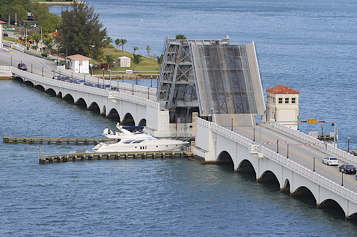
The Venetian Causeway Bridge (West) at Mile 1088.6 is first. This bridge has a 12-foot closed vertical clearance and opens on signal, except Monday through Friday (except Federal holidays) from 7:00 a.m. to 7:00 p.m., when the draw need only open on the hour and half hour. Next are the high-rise MacArthur Causeway Bridges (65-foot fixed vertical clearance) at Mile 1088.8. Once clear of the bridges you should be headed across the charted turning basin for flashing red "50" (ICW marker) located just west of Dodge Island.
To continue south on the ICW keep flashing red "50" to starboard. Off to port you will see flashing red "20" (Main Channel marker). If your intent is to follow the Main Ship Channel towards Government Cut (Miami) Inlet, keep this marker to port and turn east and out the channel. (No small boat traffic is allowed in the Main Ship Channel when the cruise ships are in and marine police diligently patrol the entrance. Monitor VHF Channel 16 for possible Sécurité warnings.) If the Main Channel is blocked proceed south on the ICW and turn east once past Dodge Island for an alternate route through the Dodge Island Cut.
If continuing south on the ICW, the course changes at flashing red "50." Adjust course to parallel the west wall of Dodge Island as you line up to pass through the next two bridge openings. The closely spaced Dodge Island Bridge and Dodge Island Railroad Bridge cross the ICW at Mile 1089.3. The fixed Dodge Island Bridge has a 65-foot vertical clearance, while the Dodge Island Railroad Bridge has a 22-foot closed vertical clearance. The railroad bridge is usually in the open position unless a train is approaching.
Once you pass these bridges keep flashing green "53" on you port side. The ICW intersects with two other channels at Mile 1089.8. To the east is Fishermans Channel, which is the alternate route to reach Government Cut (Miami) Inlet (as well as Miami Beach Marina) when the Main Ship Channel is closed. To the west is the entrance to the Miami River. Passage of these routes is described in later sections.
To continue south on the ICW, keep green daybeacon "57" and quick-flashing green "59" to port while preparing to skirt the east shore of Claughton Island.
For more information on cruising the Miami area, purchase a Print Waterway Guide Southern Edition or a Southern Subscription.