Navigating The Trent-Severn Waterway
The Trent-Severn Waterway is an intricate inland system of rivers, lakes and canals connecting Lake Ontario to Georgian Bay. In 1615, Samuel de Champlain became the first European to traverse the various rivers, lakes, waterfalls and rapids. Prior to European settlement, various First Nation tribes created the trails, river routes and portages along the valleys of the Severn and Trent Rivers. These byways provided trading routes and passages for warfare.
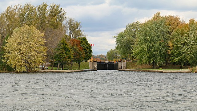
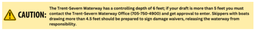
Today the 240-mile (386-km) waterway has 45 locks and 60 bridges (39 of which are swing bridges) with the lowest having a fixed vertical clearance of 22 feet (6.7 meters). Water depths (under normal conditions) are 8 feet from Locks 1 through 19 and 6 feet from Locks 20 to 45.
In addition to the natural beauty of this waterway, there are several noteworthy features including the highest hydraulic lift lock in the world (Peterborough) with a 65-foot vertical drop. The second highest is at Kirkfield, which lifts your vessel 49 feet. Finally, the Big Chute marine railway is a roller coaster for your boat that rises and falls a total of 58 vertical feet.
Parks Canada operates the Trent-Severn Waterway. Its lock and bridgetenders will help you with lock and bridge questions and tourist information. Extensive information is available at Trent-Severn Waterway National Historic Park.
Regulations & Recommendations
Be sure to use the latest Canadian small-craft nautical charts. The main small-craft route is marked with a solid red line, and alternate routes are marked with broken red lines. The circled red numbers that appear along the solid line indicate statute kilometers. A quick way to convert kilometers into statute miles is to multiply kilometers by two and divide by three. This also works for kilometer per hour speed limits. To convert to nautical miles just multiply kilometers by two. Some Canadian charts do use statute or nautical miles instead of kilometers. Be sure to check the scales and legends on every chart you use!
We also recommend you download Boating Safely before departing, which provides pertinent information on the Ontario waterways. This must-have booklet is also available at Visitor Centers and marine stores throughout the region or call the Trent-Severn Waterway office at 888-773-8888. Read it before entering the waterway for answers to many frequently asked questions and concerns about the waterway. You can get Canadian Marine Forecasts and Warnings online. Temperatures are given in Celsius. A quick way to estimate the Fahrenheit from Celsius is to multiply Celsius by 1.8 and add 32.
Do not be lulled into thinking that you are on a canal and that the weather forecast is any less necessary than elsewhere. At times you will hear a weather advisory and be told to tune to a channel on your VHF that sounds unfamiliar. Do not despair. While on the Trent-Severn system, you can get the weather on WX1, WX2, WX4, depending on your location on the system. Weather forecasts are broadcast in both English and French so if you tune in and catch the French version, just wait a bit and it will be repeated in English.
Vessels wishing to use Lock 44: Big Chute Marine Railway must adhere to the following restrictions:
- Maximum vessel length: 99.2 feet (30.5 meters)
- Maximum vessel beam (width): 24 feet (7.3 meters)
- Maximum vessel weight: 99 ton (90 metric tons)
Deeper-draft vessels must use the commercial route through the Welland Canal on the southwest shore.
There are fixed bridges on the waterway with a vertical clearance of 22 feet. Most sailboats need to un-step their masts. Depending on your approach to the waterway and the direction in which you are traveling, there are DIY or marina operated cranes from which to choose. For those boats with exceptionally tall masts, some marinas can arrange to have your mast shipped to your final destination if you choose not to carry it onboard.
For sailboats entering the Trent-Severn Waterway, the yacht club at CFB Trenton provides the only mast-stepping crane in the area and is within close proximity of the Trent-Severn and world-class Trent Port Marina. The next closest facilities are at Belleville. At the western (Severn) end of the waterway, the closest re-stepping spots are in Midland, ON, in Georgian Bay. If having a good, on-site marine supply store is important, Bay Port Yachting Centre is your choice. Most marinas provide a crane operator and a helper for a reasonable per-foot fee.
Be prepared to do most of the rigging work yourself. If you are not comfortable handling your own rigging, secure the services of a professional rigging outfit. Caution: Because your bow will swing into the lock when you use reverse to stop, many sailors prefer to have the majority of mast overhang off the stern.
Schedules & Fees
Parks Canada numbers the locks from 1 to 45, but the waterway only has 43 locks. Lock 29 disappeared when it was combined into a double hydraulic lock at Burleigh Falls and Lock 33 disappeared when it was combined into a double hydraulic lock at Fenelon Falls. Interestingly, the marine railway called the "Big Chute" is counted as a lock. Beginning with Lock 1, there are 34 locks that lift you to Balsam Lake, the highest point on the waterway. From there, Locks 36 through 45 lower you to Georgian Bay.
All types of lockpass and mooring permits may be purchased at any Trent-Severn lockstation during the navigation season or by phone (1-888-773-8888). The easiest option is to buy permits online at Parks Canada. Vessel length is used to calculate lockage and mooring fees and vessels 12 feet and under are charged a minimum rate for all permits. Locks accept cash, personal checks, VISA or MasterCard. Save your receipts.
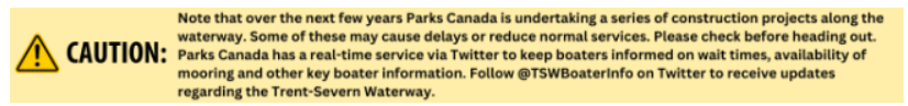
The published operating dates for the 2023 season are May 19 to October 9. Schedules vary depending on the time of year but the lock opens at 9:00 a.m. (daily), except May 19 to June 18 when it opens at 10:00 a.m. Schedules and fees are subject to change so check Parks Canada for up-to-date information.
Navigation
Canadian small-craft waters make use of spar buoys and shaped day markers. They are significantly smaller than buoys in U.S. waters. In poor visibility spar shapes are hard to distinguish without a chart check. Watch your charts closely as red and green markers switch sides under different rules on the waterway. Typically red buoys are to starboard when going upstream. Review the upcoming route for the day before casting off. Nearly a third of those boats going aground do so after taking a marker on the wrong side.
Daymarkers (markers on land) should be given more room than spars. Frequently spars are in place with day markers. This can be confusing at first but you will get used to it. The obvious solution to the confusion is to honor the spar. Common sense will tell you not to pass between a red spar and a red day mark, for example. Nevertheless, when spotting marks with binoculars it is sometimes difficult to determine that the two navigational aids are marking the same hazard.
Buoys here are small and can be next to impossible to see with a light haze or rain. Reds have pointed tops; greens flat tops. Do not try to rely on shape to identify a buoy. It is advisable to have a chartplotter onboard with the appropriate area charts. This may seem like overkill on a canal system but be advised that the entrance to Trenton from the Bay of Quinte is shallow and in recent years many entrance buoys have been removed as a cost-saving measure.
Finally, be advised that the entrance from Lock 45 out to deep water in Severn Sound is complex and unforgiving and even more so if you choose the alternate Potato Channel route for small craft.