The Outside Route: Delmarva Coast
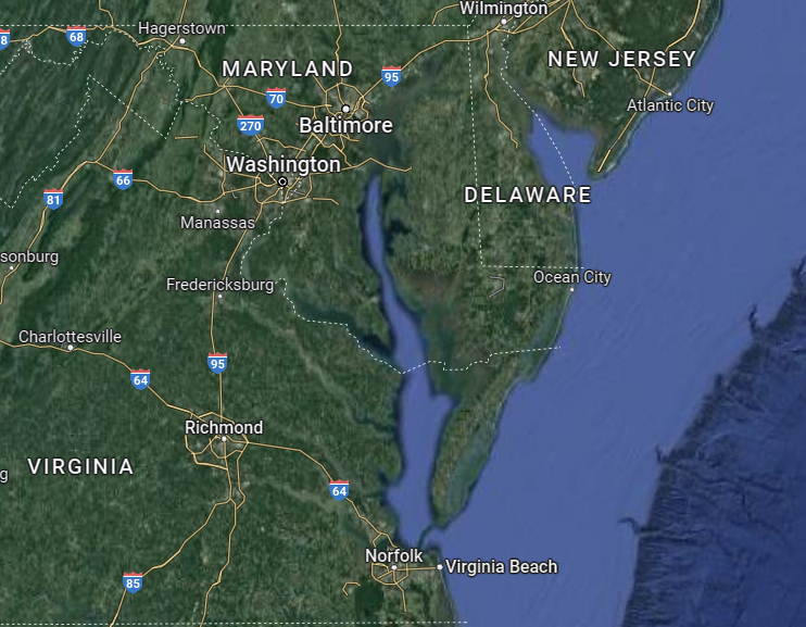
Heading north or south on the Atlantic Ocean along the Delaware, Maryland and Virginia coasts represents an alternative to navigating Chesapeake Bay, the C&D Canal and Delaware Bay. Weather, your boat's speed and draft, and your own abilities, schedule and interests will determine whether you choose to run outside along the Delmarva (Delaware-Maryland-Virginia) coast. Bypassed by most Bay travelers but used by boaters more comfortable in coastal waters, the Delmarva coast is an intriguing cruising ground.
There are a number of passable inlets along this route and with proper planning you can make this 156-nm offshore run in one day, as a two-day passage or in several hops, depending on the speed of your vessel and the weather you encounter. As always, you must have a thorough understanding of your boat, your charts and your crew's and your own abilities before running offshore. Whenever an outside run is planned you should always have a "bail out" point or two in mind should conditions change unexpectedly or an emergency arise.
Weather, of course, must be a key consideration in any offshore passage. Be careful in choosing what weather reports to heed. Although broadcasts from Baltimore and Annapolis stations easily reach across the Delmarva Peninsula, their forecasts seldom apply here because they are oriented to the Chesapeake Bay area and its more benign weather conditions. Instead, rely on weather reports from Ocean City NOAA. VHF-FM makes continuous weather broadcasts on WX-3 from Salisbury, MD; the signal extends halfway down the peninsula. Another continuous VHF-FM forecast on WX-1 from Norfolk, VA, covers the southern sector. There are also a number of weather routing services that will provide reliable reports of offshore conditions. Offshore weather forecasts are usually very different than those for inshore waters; fetch can build from offshore wind and storms and may take a day or two to lay down.
Tidal range along the Atlantic Coast of the Delmarva Peninsula averages about 4 feet but wind will affect depths as much as tide. A long easterly blow will increase it up to 3 feet, while a westerly will decrease it the same amount. Currents can be considerable throughout, particularly in and near inlets where they commonly run at velocities up to 3 knots. (Note: Residents report that the tide times on the Ocean City weather broadcast may be an hour or two off for certain areas, so inquire locally.)
The first leg for many cruisers is the 40-nm run from Cape May to Ocean City, MD. If you can clear the fixed Charles W. Cullen Bridge with 45-foot fixed vertical clearance, you could duck in 15 nm north of Ocean City in the Indian River Inlet. The next logical leg is a 35-nm run from Ocean City to Chincoteague Inlet. Cape Charles at the southern end of the Delmarva coast is a good stop for planning the next stage of your journey. Most cruisers, however, will continue into the Little Creek/Hampton/Norfolk area of Virginia for provisioning.
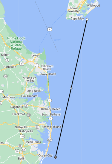
Cape May to Ocean City
Ocean City, MD, is 8 nm miles below Fenwick Light and the Delaware–Maryland state line. The city stands on the south end of Fenwick Island, the barrier of land running southward from Rehoboth Beach, DE, between the Atlantic Ocean and the Assawoman and Isle of Wight Bays. Continuing farther north into the Isle of Wright and Assawoman Bays will take you under the SR 50 Bridge over the Tuckahoe River, which is one of only a few remaining bridges in New Jersey that embody the technology of J.B. Strauss, one of the most prominent designers of movable span bridges in the early 1900s.
Ocean City is made up of high-rises, condominiums and summer homes and its harbor bustles with sport and commercial fishermen. The most serious fishing enthusiasts head for the ocean in search of marlin, tuna and wahoo. Ocean City's main attraction is the long ocean beach and boardwalk lined with shops, hotels, restaurants and an amusement park with rides, arcades and a fun house. It also includes 17 championship golf courses (on the mainland).
Ocean City to Chincoteague
It is 35 nm from the Ocean City Inlet to Chincoteague Inlet, then 17 nm to Wachapreague Inlet, then 14 nm to Great Machipongo Inlet and a final 25 nm to Cape Charles. Do not bother with the other inlets on your chart; they are far too shallow and dangerous to approach. All these inlets can be fairly nasty in moderate wind conditions with breakers on both sides of the channel and the tidal current runs quite swiftly. The marked channels through the inlets change frequently. The inlets should be attempted in calm weather only.
Unlike Ocean City, which has a highly developed resort atmosphere, Chincoteague retains the flavor of a rustic fishing village. Generations of watermen have tended the world-famous oyster beds in the waters surrounding Chincoteague Island. (The beds are privately owned and trespassing is strictly forbidden.) The bivalves harvested from these waters are world-renowned for their particularly sweet yet salty taste. Trucks leave Chincoteague daily during the "R" months (September through April) with oysters bound for New York, Europe and Japan.
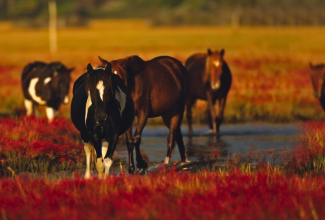
Chincoteague is also known for its wild ponies, which can be seen running on the beaches. Miles of unspoiled beaches and nature trails, along with the Assateague Lighthouse, make up the Chincoteague National Wildlife Refuge. The annual (since 1925) Pony Swim & Auction is held in July. During the pony swim event "salt water cowboys" herd the ponies across the channel at low tide. An auction takes place before the ponies swim back to Assateague Island. The auction not only provides a source of revenue for the fire company but also serves to trim the herd's numbers. Insiders recommend that the best time to see the ponies is "any other time besides during the pony swim" (due to the 40,000 spectators). Visit Assateague Island National Seashore for more information.
To Fisherman Island & Beyond
It is approximately 25 nm from Great Machipongo Inlet to the Chesapeake Bay entrance at Cape Charles. The Mockhorn Island Wildlife Management Area is between the mainland and the ocean at the south tip of the Delmarva peninsula. Mockhorn Island is an Atlantic coastal island of over 7,000 acres of tidal marshland that is only visible during low tide. The area is a bird watcher's paradise.