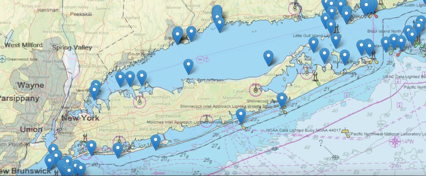
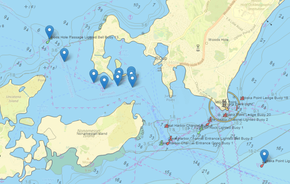
USCG Plans to Eliminate 350 Buoys in New England
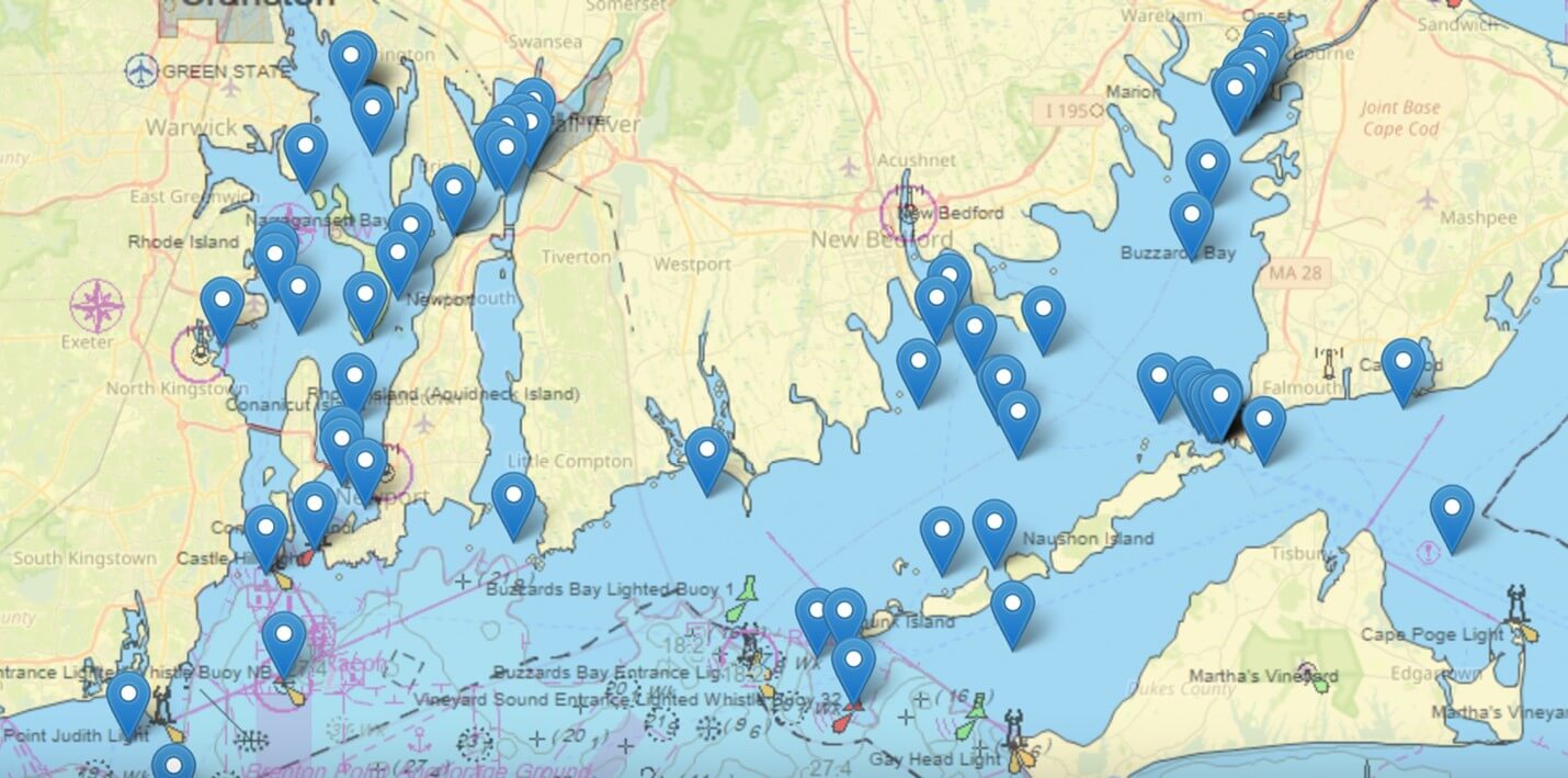
The U.S. Coast Guard has proposed a wide-reaching plan to remove or alter hundreds of navigational markers along the Northeast US coast, including buoys, day-beacons, and lights that have long helped mariners safely navigate coastal and inland waters. These changes, published in the Local Notice to Mariners (LNM) 01-16-2025, are part of an effort to streamline the Aids to Navigation (ATON) system — but many in the maritime community have raised concerns about how these removals could impact safety, access, and local knowledge. If It’s Not Broke...
For over 250 years mariners in New England have been safely navigating the waters of some of the best cruising grounds -- but also one full of potential dangers -- in the world thanks to Nav Ads maintained by the U.S. Coast Guard. By eliminating 350 of the most used buoys in the Northeast, the USCG is, in essence, requiring that all boats be equipped with electronic GPS charts, because paper charts are no longer available.
But boaters don’t navigate by chart-plotters alone! These GPS devices give boaters a good idea of where they are, but a representation on a screen is not like seeing exactly where you are in relation to a buoy. Further, positions on chart plotters are often confusing – does the plotter point to true North, or simply ahead? And, of course, the boat operator can toggle between them, precisely because charts on screen can be disorienting.
Rule #5: Keeping a Good Lookout
No longer will boaters be able to navigate by sight alone. Now, boat operators will have to have their eyes glued to the screens instead of looking out for traffic. Heretofore, if a boater kept a buoy to port or starboard, he was sure he was staying off the rocks. Now, it won’t be so easy. Boat operators simply need reference marks on the water to navigate safely.
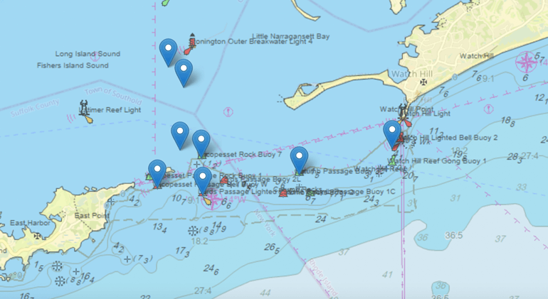
There was a good reason why everyone of the Nav Aids was put in place, and while some might be more important than others, all are used by both recreational and commercial captains. In New England, there are many critical buoys that are being taken out that mark stone ledges, rocks and other hazards that are not readily apparent.
How You Can Help Keep Boating Safe
If you’re concerned about the proposed removal of navigational markers in your area, you can make your voice heard. The U.S. Coast Guard is accepting public comments until June 13th, and feedback from mariners and local communities is critical in shaping final decisions.
To share your perspective, email [email protected] with your observations, concerns, or support regarding specific markers. Please refer to Project No. 01-25-015 in your comments. They are taking public comments until June 13th.
A Word from the USCG
“The proposal aims to support waterway safety by ensuring the right short-range aids work well with modern navigation technology,” said Matthew Stuck, the First Coast Guard District’s chief of waterways management. “Public comment about specific buoy use is essential. A sustainable buoy system ensures safety and efficiency, even during disruptions or technology failures, keeping commerce flowing smoothly.
“In the First Coast Guard District, the 350 buoys proposed for discontinuation represent about 6 percent of the 5,640 federally-maintained aids to navigation.”
See the markers planned to be removed...
To make your comments as impactful as possible, please include the type and size of your vessel (recreational or commercial), how the aid supports your navigation, and the distance at which you typically begin to rely on it.
The public is invited to comment on the plan by clicking on here