A Hurricane Barrier Near You?
Boaters in Stamford, CT – BoatTEST.com’s
home port -- have the benefit of being able to get behind an Army Corps of Engineers-made
barrier that protects their boats from a severe storm surge such as the one experienced
in the Galveston-Houston area last month. When hurricanes approach, local residents
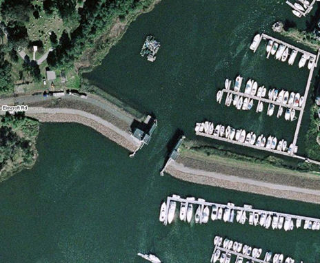
make plans to evacuate behind the doors which can close the opening seen in the picture below. The stone levee to the left and right of the doors is about 17'
above MLW.
|
|
This picture shows the Army Corps of Engineers’ hurricane barrier in the east branch of Stamford, CT Harbor. Large, steel doors close when the Corps expects the high water of a storm surge. |
|
|
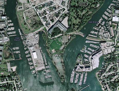
Stamford Harbor has two branches of the harbor that lead into canals that date back to the 1700s when the town was a bustling port for square-riggers. The levee protects the east canal and most of the land between the two canals. |
In 1955 a hurricane hit the western Long Island Sound area and flooded an extensive
portion of downtown Stamford, putting underground infrastructure – water mains,
utilities, sewage pipes – at risk, to say nothing of flooding residential and commercial
property. By 1967, under a federally-financed flood prevention program a levee was
completed protecting the Stamford area south of I-95 and the New Haven RR tracks.
A happy consequence of this flood-control project was the hurricane barrier and
doors on the east branch of Stamford Harbor. It is an ideal refuge for yachts and
when hurricanes approach local boat owners make plans to move their boats behind
the doors in the east canal. Stamford has its own man-made hurricane hole.
|
|
This view shows all of Stamford Harbor. Note the mooring field in the center of the picture. There is room behind the hurricane barrier for all of the boats in Stamford Harbor. The “V”-shaped line at the bottom of the picture is a breakwater that protects the harbor during normal conditions. |
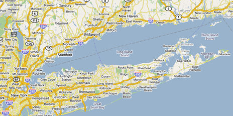
Long Island Sound is like a huge funnel, with a relatively large opening at the
eastern end called the Race and Fisher’s Island Sound. But at the western end, all
of the water in the Sound must evacuate through New York City’s East River which
is quite narrow. The northeasterly winds of a hurricane push water up the Sound
toward New York City, which can flood low-lying areas along the Sound. This surge,
combined with moon tide – or worse yet – a second moon tide, would mean big trouble for
Stamford.
While the levee system would never have been put in just for yachtsmen, they are
among the beneficiaries of this flood control project. The lessons here seem obvious.
|
|
Open from Montauk to Watch Hill on the eastern end, Long Island Sound funnels water into New York City’s narrow East River at the western end which can cause a high storm surge and flooding. |
Please tell us about your own local hurricane holes and about your emergency plans
to protect your boat…