10 Best Boating Apps
Today’s cell phones are also navigational and safety devices that can come in quite handy for boaters. They can help us get where we’re going faster, stay out on the water longer, and as a result possibly even help us catch more fish. Most importantly, they can serve as life-saving devices in emergency situations. If, that is, you have the right apps. Whether you love smart phones or hate ‘em, you’ll want to have some or all of these 10 apps on your device.
Apps for Safety
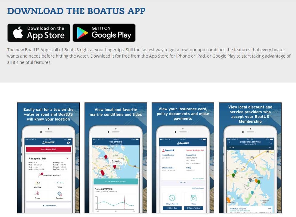
SeaTow- The SeaTow app provides ample tools and features that will allow you to enjoy your day on the water. It offers key safety functions, such as the compass and speedometer that will pinpoint your exact location. If boaters need on-water assistance, they can contact the 24-hour SeaTow Dispatch Center, where captains are on standby. Aside from safety features, SeaTow delivers detailed weather and tide forecasts, moon phases and the next tide countdown right to your phone. Another app with several similar features is BoatUS, which provides towing assistance, weather, tides and marine conditions to name a few. In both cases, the app is free. https://www.seatow.com/tools-and-education/app https://www.boatus.com/membership/app/
Lightning Tracker Pro- This app costs a mere $2.99, and helps you see exactly where lightning strikes are taking place. You can also set it up to alert you if a storm is nearby and lightning pops up in your area. It’s limited in its utility for sure, especially considering how many general weather apps are on the market – but if you want to make sure you’re not around when the lightning strikes, this is the app for you. https://play.google.com/store/apps/details?id=com.jrustonapps.mylightningtrackerpro
Morse SOS- This one is like the flashlight app that so many people have but instead of shining non-stop, it blinks out an SOS. As a signaling device, the utility is obvious and this app has already been credited with more than one rescue on the water. Plus, this one’s another freebie for both iOS and Android users. https://play.google.com/store/apps/details?id=com.livingwatersw.android.morsesos
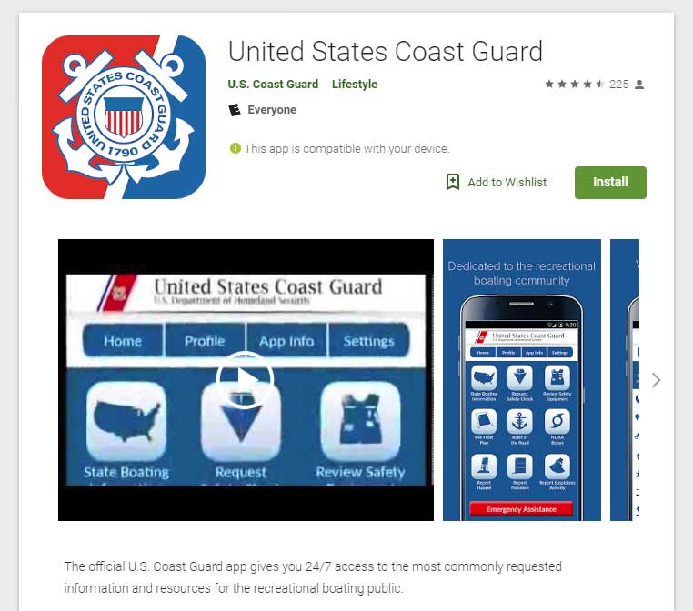
Coast Guard- Yes, even the USCG now has its own boating safety app. They remind us never to rely on a cell phone as your primary means of emergency communications on a boat, (of course!) but if you have a cell phone with this app installed onboard you can use it to get their attention in a hurry. You can also use it to file a float plan, request a USCG Auxiliary safety inspection, check state-by-state boating regs, and more. Yes, this one’s cost-free, too. http://uscgboating.org/mobile/
RadarNow!/Weather Underground/WeatherBug- there are a ton of weather apps out there, some of which are free and others which carry a fee. Everyone seems to have their favorite and we’re not going to make a judgement call as to which is “best” — the important thing is just that you have one. Real-time weather radar, wind forecasts, and sunrise/sunset/tidal information are some of the big benefits.
WeatherBug forecasts for 2.6 million+ locations worldwide from 10,000+ professional-grade weather stations. It is able to pinpoint where you are located and provide the most accurate current, hourly and 10-day forecasts. The app uses 18 different weather maps such as lightning, wind, Doppler radar, pressure, temperature and humidity. It also keeps you updated with air quality and pollen count. You can download the app for free and customize your alerts. https://www.weatherbug.com/weather-forecast/now/
Apps for Navigation
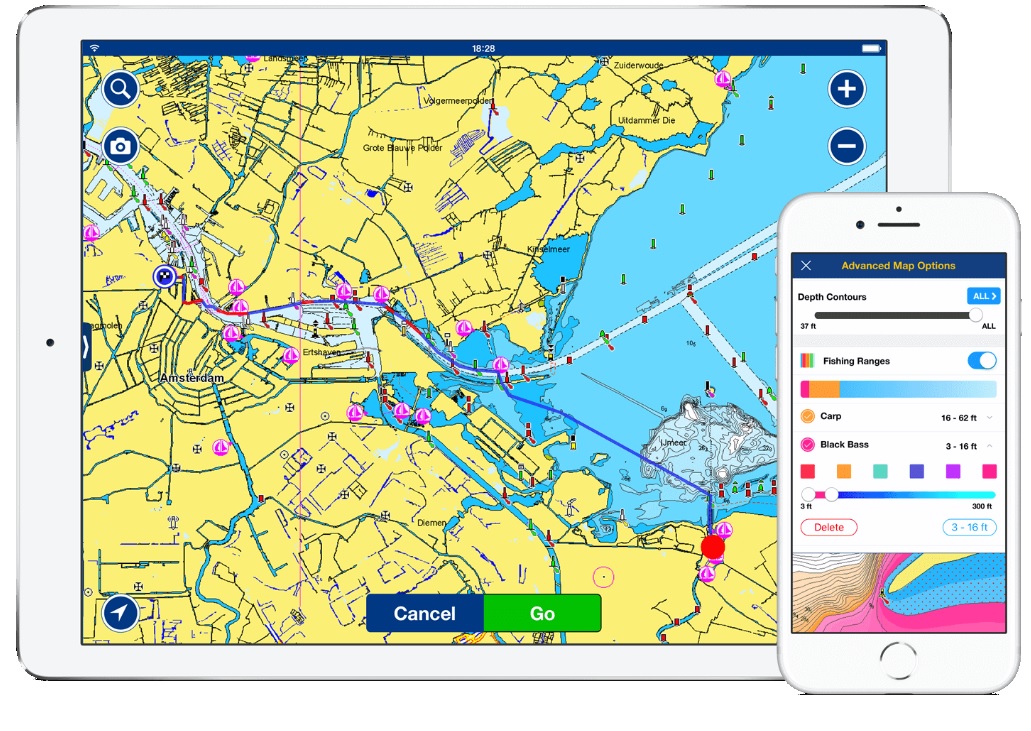
Navionics– This is the stand-by king of all nav apps and calls itself “the world’s number one boating app.” We don’t doubt it. It essentially turns your cell phone or tablet into a fully-functional chartplotter. Not only does it use Navionics chartography, it also has a community layer with real-world updates from users. The latest advance is SonarChart Live, which can pull depth soundings and GPS position from a fishfinder via WiFi and create real-time chartography updates. Pricing varies by the area, and charts for certain areas (outside of the US) cost more, but $15 is about average for most zones. These are also some advanced functions, like auto-routing, which result in additional charges. https://www.navionics.com/usa/apps/navionics-boating
C-Map Embark App – C-Map has their own way to turn your device into a chartplotter. The basic (free) app has in-app purchases, and one nice perk is that you can download charts then use them offline. Embark also provides AIS data, weather info, and marina/harbor info. http://lightmarine.c-map.com/mobile/c-map-embark-app
Ship Finder – For most of us, buying a full-blown AIS (automatic identification system) for our boat doesn’t make sense. But there may still be times when you’d like to know the course and bearing of a ship coming through the bay, or the location of a commercial boat. With Ship Finder you get it, right on your phone, in real time. Ship Finder also shows you data like the vessel’s speed, name, MMSI number and more. Cost is $3.99. https://shipfinder.co/about/
Other Useful Apps
Boat Ramps – With the first created by the Recreational Boating and Fishing Foundation, there are a number of boat ramp apps that will show you the closest ramp to your current location or to a destination you want to visit. We’re not going to specify which you need because most are based on the ramps in a particular state. These are mostly free, though some charge a buck or so. Just visit Google Play or the App Store, and you’ll have no trouble searching up the boat ramp app that’s right for the state you live in.
There is an app called Boat Ramps that provides users with more than 50,000 boat ramps and marinas worldwide, shown to users on a map with ramp and marina totals in each area. To get a more detailed search of a certain location, zoom in with the touch of your fingers. Boat Ramps is free until you want to access premium features, such as hyper-localized fishing forecasts, catch tracking, fishing reports and more. Boat Ramps offers a three-day free trial of the premium features. If you are interested in the premium, there is either a monthly membership of $2.99 or an annual charge of $29.99. https://itunes.apple.com/us/app/boat-ramps/id333176419?mt=8
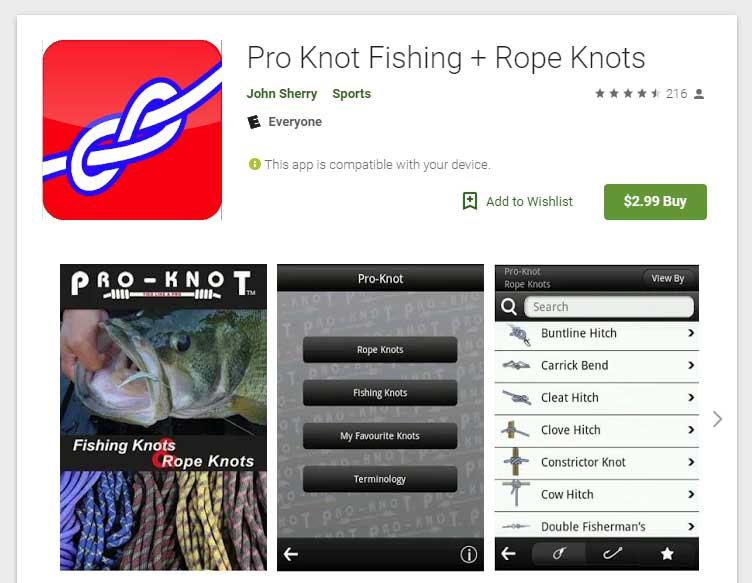
Pro-Knot- With this app on your phone, the next time some wise-guy bets you can’t tie a Bimini Twist you can prove him wrong. With a little help from your phone, of course. For the $2.99 cost of this app you can see step-by-step illustrations on how to tie 100+ different knots. https://www.proknot.com/#section-knots-app
We can vouch for the usefulness of all the apps included here. They’ve all been around long enough to be tested and vetted, and all are extremely helpful. However, if you have found some other useful Apps for boaters, please let us know. Click here...
If none of these 10 apps does exactly what you want, don’t worry—there’s surely one or three or 50 out there that you’ll find useful. In fact, there are literally dozens of apps that fall into each of these categories. Just go to the App Store or Google Play, and start playing.
That said, do you have a favorite boating app? Let us know here.